IMAGES TAKEN NEAR TO
Fore Street, NEWTON ABBOT, TQ13 0GZ
Introduction
This page details the photographs taken nearby to Fore Street, TQ13 0GZ by members of the Geograph project.
The Geograph project started in 2005 with the aim of publishing, organising and preserving representative images for every square kilometre of Great Britain, Ireland and the Isle of Man.

There are currently over 7.5m images from over14,400 individuals and you can help contribute to the project by visiting https://www.geograph.org.uk
Image Map
Images are licensed for reuse under creativecommons.org/licenses/by-sa/2.0
Notes
- Clicking on the map will re-center to the selected point.
- The higher the marker number, the further away the image location is from the centre of the postcode.
Image Listing (103 Images Found)
Images are licensed for reuse under creativecommons.org/licenses/by-sa/2.0
Image
Details
Distance
1
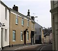
Clifford Street, Chudleigh
A view along the winding street of terraced cottages from Conduit Square.
Image: © Derek Harper
Taken: 16 Mar 2009
0.02 miles
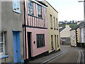
2
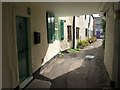
Old Pottery Court, Chudleigh
A close that opens off Conduit Square in the centre of Chudleigh. On the left is part of 7, Fore Street https://historicengland.org.uk/listing/the-list/list-entry/1097100 . At the far end of the close is a photographic studio.
Image: © Derek Harper
Taken: 16 Mar 2009
0.02 miles
3
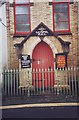
The Gospel Hall, Chudleigh, Devon.
As can be seen in the photo, the chapel had just closed, but the message remained.....!
Image: © nick macneill
Taken: 11 Apr 1996
0.02 miles
4
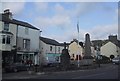
War memorial in the centre of Chudleigh
Image: © Sarah Charlesworth
Taken: 29 Oct 2009
0.03 miles
5
Orange Way in Devon and Torbay (159)
This is the main road in Chudleigh looking north east.
To proceed to the next section of the Orange Way go to www.geograph.org.uk/geotrips/424.
Image: © Shazz
Taken: 20 Oct 2011
0.03 miles
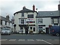
6
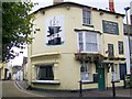
The Ship Inn, Chudleigh
The pub has a fantastic sign painted on the front.
Image: © Maigheach-gheal
Taken: 17 Aug 2008
0.03 miles
8
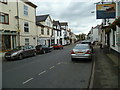
Clifford Street
This road used to be often chaotic as a through road before it was blocked off at one end.
Image: © paul dickson
Taken: 26 Feb 2008
0.03 miles
9
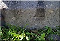
Ordnance Survey Cut Mark
This OS cut mark can be found on the monument in the Square. It marks a point 71.552m above mean sea level.
Image: © Adrian Dust
Taken: 25 Mar 2019
0.04 miles
10
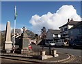
Memorial Old Exeter Street Chudleigh
The War Memorial at the junction of Old Exeter Street and the B3344 at Chudleigh
Image: © Steve Houldsworth
Taken: 4 Mar 2016
0.04 miles