IMAGES TAKEN NEAR TO
Apple Tree Close, NEWTON ABBOT, TQ13 0FE
Introduction
This page details the photographs taken nearby to Apple Tree Close, TQ13 0FE by members of the Geograph project.
The Geograph project started in 2005 with the aim of publishing, organising and preserving representative images for every square kilometre of Great Britain, Ireland and the Isle of Man.

There are currently over 7.5m images from over14,400 individuals and you can help contribute to the project by visiting https://www.geograph.org.uk
Image Map
Images are licensed for reuse under creativecommons.org/licenses/by-sa/2.0
Notes
- Clicking on the map will re-center to the selected point.
- The higher the marker number, the further away the image location is from the centre of the postcode.
Image Listing (67 Images Found)
Images are licensed for reuse under creativecommons.org/licenses/by-sa/2.0
Image
Details
Distance
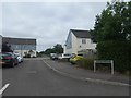
2
New houses, Chudleigh Knighton
A new estate on the west side of the village by the B3344 road to Bovey.
Image: © Derek Harper
Taken: 12 Dec 2010
0.02 miles
3
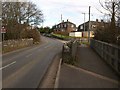
Bridge on west edge of Chudleigh Knighton
A bridge with stone parapets over a small stream that runs to the Teign. A modern footbridge protects pedestrians, important because there is a children's playground on the side furthest from the village.
Image: © David Smith
Taken: 12 Jul 2013
0.03 miles
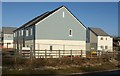
5
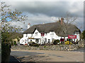
Claycutters Arms at Chudleigh Knighton
Pub and restaurant with nice thatched roof.
Image: © paul dickson
Taken: 31 Mar 2008
0.04 miles
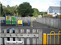
6
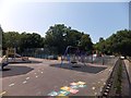
Children's playground, Chudleigh Knighton
Image: © David Smith
Taken: 12 Jul 2013
0.04 miles
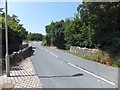
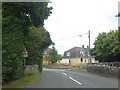
7
Bridge in Chudleigh Knighton
The B3344 crosses a small tributary of the Teign as it enters the village.
Image: © Derek Harper
Taken: 17 Feb 2009
0.05 miles
8
Bridge on west edge of Chudleigh Knighton
Seen from the west; the reverse view is at Image
Image: © David Smith
Taken: 15 Jul 2020
0.05 miles
9
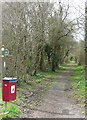
Chudleigh Knighton - bridleway
This path is located next to the playpark and runs parallel to the dangerous road before heading towards Knighton Heath.
Image: © paul dickson
Taken: 26 Mar 2008
0.08 miles
10
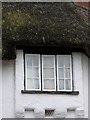
Window details, Clay Cutters Arms
Under the window is a date stone giving the date of 1666.
Image: © Maigheach-gheal
Taken: 17 Aug 2008
0.08 miles