IMAGES TAKEN NEAR TO
Gales Crest, NEWTON ABBOT, TQ13 0EZ
Introduction
This page details the photographs taken nearby to Gales Crest, TQ13 0EZ by members of the Geograph project.
The Geograph project started in 2005 with the aim of publishing, organising and preserving representative images for every square kilometre of Great Britain, Ireland and the Isle of Man.

There are currently over 7.5m images from over14,400 individuals and you can help contribute to the project by visiting https://www.geograph.org.uk
Image Map
Images are licensed for reuse under creativecommons.org/licenses/by-sa/2.0
Notes
- Clicking on the map will re-center to the selected point.
- The higher the marker number, the further away the image location is from the centre of the postcode.
Image Listing (72 Images Found)
Images are licensed for reuse under creativecommons.org/licenses/by-sa/2.0
Image
Details
Distance
1
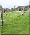
Churchyard, St Paul's Church, Chudleigh Knighton
The other side of the churchyard is the thatched roof of the Claycutters Arms.
Image: © Maigheach-gheal
Taken: 17 Aug 2008
0.02 miles
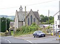
2
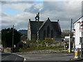
Chudleigh Knighton Church
Heading towards Bovey Tracey from Chudleigh, the sign sensibly directs traffic away from the more direct route past the school. The impressive pebble walled church dominates this photograph.
Image: © paul dickson
Taken: 31 Mar 2008
0.03 miles
3
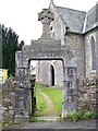
Gate, St Paul's Church, Chudleigh Knighton
The arch to the gate is the village War Memorial.
Image: © Maigheach-gheal
Taken: 17 Aug 2008
0.03 miles
4
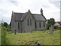
St Paul's Church, Chudleigh Knighton
The church stands in a large churchyard.
Image: © Maigheach-gheal
Taken: 17 Aug 2008
0.03 miles
5
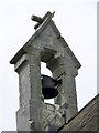
Bell turret, St Paul's Church, Chudleigh Knighton
Image: © Maigheach-gheal
Taken: 17 Aug 2008
0.03 miles
6
St Paul's Church, Chudleigh Knighton
The church stands on the junction near the school, the village pub and post office.
Image: © Maigheach-gheal
Taken: 17 Aug 2008
0.03 miles
7
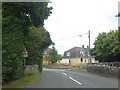
Bridge on west edge of Chudleigh Knighton
Seen from the west; the reverse view is at Image
Image: © David Smith
Taken: 15 Jul 2020
0.03 miles
8
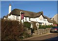
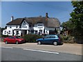
Clay Cutters Arms, Chudleigh Knighton
A view of http://www.geograph.org.uk/search.php?i=17654797 from a different angle. The old thatched pub is described in enormous detail at http://www.britishlistedbuildings.co.uk/en-84564-clay-cutters-arms-hennock .
Image: © Derek Harper
Taken: 12 Dec 2010
0.03 miles
9
The Claycutterr's Arms, Chudleigh Knighton
Image: © David Smith
Taken: 12 Jul 2013
0.03 miles
10
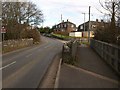
Bridge in Chudleigh Knighton
The B3344 crosses a small tributary of the Teign as it enters the village.
Image: © Derek Harper
Taken: 17 Feb 2009
0.04 miles