IMAGES TAKEN NEAR TO
Chudleigh, NEWTON ABBOT, TQ13 0DT
Introduction
This page details the photographs taken nearby to TQ13 0DT by members of the Geograph project.
The Geograph project started in 2005 with the aim of publishing, organising and preserving representative images for every square kilometre of Great Britain, Ireland and the Isle of Man.

There are currently over 7.5m images from over14,400 individuals and you can help contribute to the project by visiting https://www.geograph.org.uk
Image Map
Images are licensed for reuse under creativecommons.org/licenses/by-sa/2.0
Notes
- Clicking on the map will re-center to the selected point.
- The higher the marker number, the further away the image location is from the centre of the postcode.
Image Listing (13 Images Found)
Images are licensed for reuse under creativecommons.org/licenses/by-sa/2.0
Image
Details
Distance
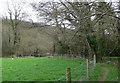
1
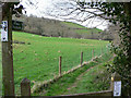
Path from Ranscombe to Trusham
Mid April is the best time to walk this path which goes along a stream, across a paddock, into the woods and on to the beautiful village of Trusham. This photograph is taken from the start of the walk by the road. I could not believe it, within 5 minutes I had seen a fox, horses, sheep, brown and black rabbits, and some deer!
Image: © paul dickson
Taken: 10 Apr 2008
0.08 miles
2
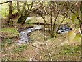
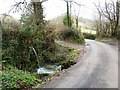
Stream near Lower Ranscombe
The stream winds along below the road.
Image: © Tom Jolliffe
Taken: 28 Feb 2011
0.09 miles
3
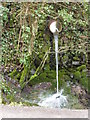
Water culvert from field
There has been a lot of rain recently. I do not know how much this affects this particular flow of water, but it seems likely that it would be affected by an increase in surface water.
Image: © Tom Jolliffe
Taken: 28 Feb 2011
0.10 miles
4
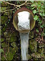
Water culvert
There is something mesmerising about the flowing of water, even in its simplest form where it drains out from a raised field and joins the flow of water in a ditch and beneath the road. The play of light on the water also attracts the attention.
Image: © Tom Jolliffe
Taken: 28 Feb 2011
0.10 miles
5
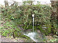
Water culvert
The run off of the stream from the field creates a small waterfall which runs underneath the road.
Image: © Tom Jolliffe
Taken: 28 Feb 2011
0.10 miles
6
Bird on a bendy twig!
Looking north from the path there is a large vegetable plot. In the middle is a bird (wooden, though I thought it real at first) attached to a springy twig!
Image: © paul dickson
Taken: 10 Apr 2008
0.11 miles
7
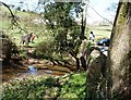
Bramble Bridge
The stream is Bramble Brook, which is joined by Oxencombe Brook just below this bridge. Bramble Brook joins the Teign at Crocombe Bridge.
Image: © David Gearing
Taken: 23 Apr 2013
0.14 miles
8
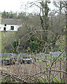
Lane near Ranscombe
The roads in this area are twisting, narrow and of varying quality.
Image: © Tom Jolliffe
Taken: 28 Feb 2011
0.15 miles
9
Ranscombe wooden bridge
This path goes left and then right over the stream via a wooden bridge heading towards Trusham.
Image: © paul dickson
Taken: 10 Apr 2008
0.15 miles
10
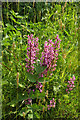
Orchid near Shortridge
Orchis mascula, the early purple orchid, has been captured elsewhere in this valley at Image This specimen is by the entrance lane to the farm, beside where Image] was taken. "There is a dizzying array of local names for the Early Purple Orchid. These include Adder's meat, Bloody butchers, Blue butches, Red butchers, Goosey ganders, Kecklegs, Kettle cases and Kite's legs ... Gethesmane and Cross-flower" https://www.plantlife.org.uk/uk/discover-wild-plants-nature/plant-fungi-species/early-purple-orchid .
Image: © Derek Harper
Taken: 21 May 2018
0.21 miles