IMAGES TAKEN NEAR TO
Chudleigh, NEWTON ABBOT, TQ13 0DG
Introduction
This page details the photographs taken nearby to TQ13 0DG by members of the Geograph project.
The Geograph project started in 2005 with the aim of publishing, organising and preserving representative images for every square kilometre of Great Britain, Ireland and the Isle of Man.

There are currently over 7.5m images from over14,400 individuals and you can help contribute to the project by visiting https://www.geograph.org.uk
Image Map
Images are licensed for reuse under creativecommons.org/licenses/by-sa/2.0
Notes
- Clicking on the map will re-center to the selected point.
- The higher the marker number, the further away the image location is from the centre of the postcode.
Image Listing (14 Images Found)
Images are licensed for reuse under creativecommons.org/licenses/by-sa/2.0
Image
Details
Distance
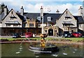
1
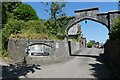
Widdehayes Cottages, Harcombe
View across the Kate Brook valley to buildings on the lane from Harcombe House to Chudleigh.
Image: © Derek Harper
Taken: 8 May 2006
0.07 miles
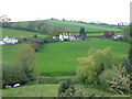
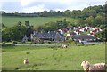
2
Harcombe
View from Sticksend Lane across the Kate Brook valley, with Harcombe House prominent.
Image: © Derek Harper
Taken: 8 May 2006
0.08 miles
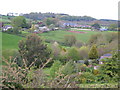
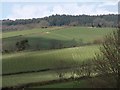
3
Kate Brook valley, Harcombe
Sticksend Lane drops into the valley. The wood on the horizon is Ducksmoor Covert in the next square.
Image: © Derek Harper
Taken: 8 May 2006
0.10 miles
4
Harcombe House
This site is owned by the Firemans Benevolent Trust and has a chalet complex at the rear which are used for holiday lets. The building was undergoing renovation work when this picture was taken.
Image: © Mike Crowe
Taken: 8 Jun 2005
0.11 miles
5
The firefighters Charity, at Harcombe House
Rest, rehabilitation and leisure for fighters and their families.
Image: © Roger Cornfoot
Taken: 19 Jul 2021
0.15 miles
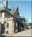
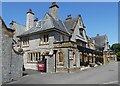
6
Harcombe House
From Chudleigh Footpath 4. Harcombe House was purchased by what is now the Fire Fighters Charity in 1981. https://historicengland.org.uk/listing/the-list/list-entry/1097130 describes the building as "an imposing house of 1912, very complete externally and with most of its interior features intact" ; the small service range building to the left is also listed https://historicengland.org.uk/listing/the-list/list-entry/1164239 .
Image: © Derek Harper
Taken: 23 May 2006
0.16 miles
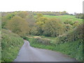
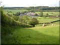
7
Fields above Harcombe
A long-distance shot of fields on the south-western slopes of Great Haldon, taken from a ridgetop lane south of Mistletoe Farm.
Image: © Derek Harper
Taken: 30 Mar 2008
0.17 miles
9
Main Building Harcombe House
Set in 300 acres of stunning gardens, lakes and woodlands, Harcombe House - owned and operated by The Fire Fighters Charity - is the ideal location for a relaxing break. Offering holiday makers the opportunity to enjoy a peaceful holiday in Devon’s glorious countryside, while also supporting injured fire fighters across the UK, Harcombe House is just 12 miles south of the historic city of Exeter.
Image: © Steve Houldsworth
Taken: 4 Mar 2016
0.18 miles
10
Harcombe House
Taken from the point at which the footpath up the Kate Brook valley leaves a track and turns north across fields, this shows Harcombe House on the far side of the stream, and the bungalows beside it that together form a recuperative centre for the Fire Services National Benevolent Fund. Beyond, the woods of Haldon.
Image: © Derek Harper
Taken: 23 May 2006
0.20 miles