IMAGES TAKEN NEAR TO
Chudleigh, NEWTON ABBOT, TQ13 0BT
Introduction
This page details the photographs taken nearby to TQ13 0BT by members of the Geograph project.
The Geograph project started in 2005 with the aim of publishing, organising and preserving representative images for every square kilometre of Great Britain, Ireland and the Isle of Man.

There are currently over 7.5m images from over14,400 individuals and you can help contribute to the project by visiting https://www.geograph.org.uk
Image Map
Images are licensed for reuse under creativecommons.org/licenses/by-sa/2.0
Notes
- Clicking on the map will re-center to the selected point.
- The higher the marker number, the further away the image location is from the centre of the postcode.
Image Listing (10 Images Found)
Images are licensed for reuse under creativecommons.org/licenses/by-sa/2.0
Image
Details
Distance
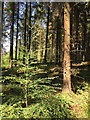
1
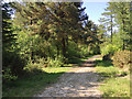
A ride in Haldon Forest west of Ashcombe Cross
The soundscape: birdsong. Dense pine and Norway Spruce forest to the right blocks traffic noise from the fast A380 about 800 metres away. Just here there is a stand of larch. To the left, oak, pine and birch and a short ride down to a track for forestry operations. The ride pictured seems to have been laid out for public access. It reaches a hairpin downslope then leads back to the unsigned car park Image No map seems to show exactly the paths and rides as they exist on the ground. The surface shows much broken flint: see Image
Image: © Robin Stott
Taken: 19 May 2018
0.09 miles
2
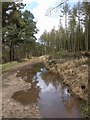
Puddle near Waddon Brakes
This well-made-up, if wet, track follows close to the perimeter of the triangular-shaped section of Haldon Forest between Ashcombe Cross, Beggar's Bush and Waddon Brakes.
Image: © Derek Harper
Taken: 30 Mar 2008
0.10 miles
3
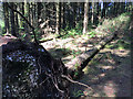
Fallen Norway Spruce, Haldon Forest west of Ashcombe Cross
The shallow root-plate is speckled with broken flints. "Sands and gravels of possibly Tertiary age and marine origin occur at 800 ft. O.D. on the Haldon Hills … much of the gravel consists of more or less worn masses of Chalk flint … although the nearest Chalk outlier now lies 15 miles away to the east" (British Regional Geology: South-West England). At some point this land was deemed suitable for forestry but trees falling over must always have been a risk. A map of 1906 shows heathland on this Haldon summit, with small fields and blocks of deciduous woodland on the slopes. The next map is not until 1954, showing the land afforested.
Image: © Robin Stott
Taken: 19 May 2018
0.18 miles
4
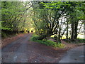
Junction near Waddon Brakes
A forked lane junction not far from the A380, looking into the last light of the day.
Image: © Derek Harper
Taken: 8 May 2006
0.19 miles
5
Young conifer among mature Norway Spruce, Haldon Forest
Either natural regeneration is taking place or there has been some underplanting, using the spruce as a shade-casting nurse. The foliage and the elegant form suggest Western Hemlock (Tsuga heterophylla). The foliage is similar to Yew but of varying length.
Image: © Robin Stott
Taken: 19 May 2018
0.21 miles
6
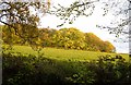
Field and wood, Waddon Brakes
Looking across the field shown in Image from the lane on the right of it.
Image: © Derek Harper
Taken: 8 May 2006
0.21 miles
7
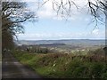
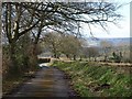
Lane to Kerswell Cross
The lane, overhung with beech trees, runs beside an unnamed wood on the left, with wonderful views ahead across Chudleigh to the Teign valley and Dartmoor.
Image: © Derek Harper
Taken: 30 Mar 2008
0.21 miles
8
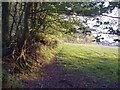
Edge of field near Waddon Brakes
This must have been taken from the same spot as Image, looking to the left along the top edge of the field; the horses in Image are riding along the lane which runs behind the field boundary.
Image: © Derek Harper
Taken: 8 May 2006
0.21 miles
9
Lane to Kerswell Cross
A little further down Image The wood on the left comes to an end just before the bend where the walker is.
Image: © Derek Harper
Taken: 30 Mar 2008
0.23 miles
10
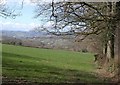
Field near Thorns Cross
Taken from beside the lane junction shown in Image; on the right, behind the beeches, is the lane shown in Image An expansive view opens out behind, with countryside near Chudleigh, and the Teign valley and Dartmoor beyond.
Image: © Derek Harper
Taken: 30 Mar 2008
0.25 miles