IMAGES TAKEN NEAR TO
Ideford, Chudleigh, NEWTON ABBOT, TQ13 0BG
Introduction
This page details the photographs taken nearby to TQ13 0BG by members of the Geograph project.
The Geograph project started in 2005 with the aim of publishing, organising and preserving representative images for every square kilometre of Great Britain, Ireland and the Isle of Man.

There are currently over 7.5m images from over14,400 individuals and you can help contribute to the project by visiting https://www.geograph.org.uk
Image Map
Images are licensed for reuse under creativecommons.org/licenses/by-sa/2.0
Notes
- Clicking on the map will re-center to the selected point.
- The higher the marker number, the further away the image location is from the centre of the postcode.
Image Listing (118 Images Found)
Images are licensed for reuse under creativecommons.org/licenses/by-sa/2.0
Image
Details
Distance


4
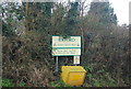
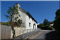
Path leaves the road
The sign points the way from Fore Street to the start of the footpath. The house is called Town's End.
Image: © Michael Dibb
Taken: 30 May 2017
0.05 miles


8
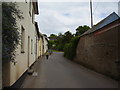
Fore Street, Ideford
Note the farm walls on the right. They appear to have grown in height over the years.
Image: © Anthony Vosper
Taken: 11 Jun 2015
0.06 miles
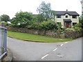
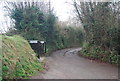
10
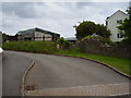
Farm buildings at Town's End
A footpath branches off to the right.
Image: © Anthony Vosper
Taken: 11 Jun 2015
0.07 miles