IMAGES TAKEN NEAR TO
Chudleigh, NEWTON ABBOT, TQ13 0AA
Introduction
This page details the photographs taken nearby to TQ13 0AA by members of the Geograph project.
The Geograph project started in 2005 with the aim of publishing, organising and preserving representative images for every square kilometre of Great Britain, Ireland and the Isle of Man.

There are currently over 7.5m images from over14,400 individuals and you can help contribute to the project by visiting https://www.geograph.org.uk
Image Map
Images are licensed for reuse under creativecommons.org/licenses/by-sa/2.0
Notes
- Clicking on the map will re-center to the selected point.
- The higher the marker number, the further away the image location is from the centre of the postcode.
Image Listing (26 Images Found)
Images are licensed for reuse under creativecommons.org/licenses/by-sa/2.0
Image
Details
Distance
1
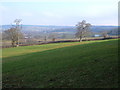
Grealy Barn
A view from Chudleigh Footpath 16, which passes through a small wood in the southwest corner of a steep field. At the foot of the field is the road between Chudleigh and Biddlecombe Cross. As with Image, taken further down the same path, the blue farmhouse at Burrows is across the field.
Image: © Derek Harper
Taken: 19 Mar 2006
0.04 miles
2
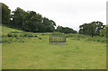
Cattle feeder in the Devon rain
A view of a wet field after a heavy shower at Biddleccombe cross.
Image: © roger geach
Taken: 6 Sep 2011
0.07 miles
3
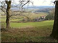
View near Chudleigh
The blue farmhouse is Burrows. Looking NE from the path below Castle Dyke. 7:12 am
Image: © Derek Harper
Taken: 19 Mar 2006
0.10 miles
4
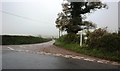
Biddlecombe Cross
On a murky November afternoon
Image: © David Gearing
Taken: 16 Nov 2012
0.10 miles
5
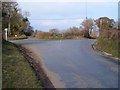
Biddlecombe Cross
A ridgetop junction, where a well-used road between the A380 at Wapperwell and Chudleigh crosses between valleys. Seen from the lane from Beggar's Bush.
Image: © Derek Harper
Taken: 19 Mar 2006
0.11 miles
6
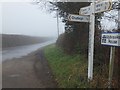
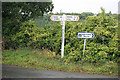
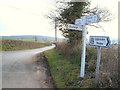
Signs at Biddlecombe Cross
For some reason, the cross symbol on the upright has been erased. There are fingerposts for three of the four roads; one minor road is ignored.
Image: © David Smith
Taken: 13 Mar 2012
0.12 miles
7
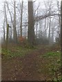
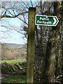
Footpath through Smoothway Wood to Biddlecombe
Image: © David Smith
Taken: 13 Mar 2012
0.12 miles
8
Biddlecombe Cross
Identical to the scene in Image and showing that the cross symbol was rather faded six years earlier. This image was also taken in clearer conditions, showing the lane to Beggar's Bush from which Image] was taken.
Image: © Derek Harper
Taken: 19 Mar 2006
0.12 miles
9
Looking past sign towards Grealy Quarry (disused)
Notice that the sign has been shot at (using presumably an air pistol).
The path goes towards Ugbrooke.
Image: © paul dickson
Taken: 12 Mar 2008
0.12 miles