IMAGES TAKEN NEAR TO
Ashton Terrace, Ilsham Road, TORQUAY, TQ1 2NP
Introduction
This page details the photographs taken nearby to Ashton Terrace, Ilsham Road, TQ1 2NP by members of the Geograph project.
The Geograph project started in 2005 with the aim of publishing, organising and preserving representative images for every square kilometre of Great Britain, Ireland and the Isle of Man.

There are currently over 7.5m images from over14,400 individuals and you can help contribute to the project by visiting https://www.geograph.org.uk
Image Map
Images are licensed for reuse under creativecommons.org/licenses/by-sa/2.0
Notes
- Clicking on the map will re-center to the selected point.
- The higher the marker number, the further away the image location is from the centre of the postcode.
Image Listing (203 Images Found)
Images are licensed for reuse under creativecommons.org/licenses/by-sa/2.0
Image
Details
Distance
1
Ashton Terrace, Wellswood
The terrace shown in Image] from the other direction.
Image: © Derek Harper
Taken: 11 Mar 2016
0.00 miles
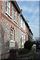
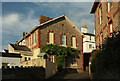
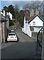
2
Ashton Terrace, Wellswood
The southwest end of a terrace of 7 properties, on a street that forms a little crescent on the hillside.
Image: © Derek Harper
Taken: 11 Mar 2016
0.02 miles
3
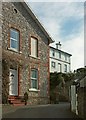
Ashton Terrace, Wellswood
The end (at the southwest) terrace; the detached house above is on Kent's Road.
Image: © Derek Harper
Taken: 11 Mar 2016
0.02 miles
4
Ilsham Mews, Wellswood
Looking left from Image
Image: © Derek Harper
Taken: 14 Aug 2021
0.02 miles
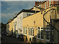
5
Ashton Terrace, Wellswood
A wider view than Image The house on the right is on Ashburne Villas, an address that seems to elude most map-makers.
Image: © Derek Harper
Taken: 14 Aug 2021
0.02 miles
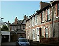
6

Houses, Wellswood
Part of a terrace of eight on Ilsham Road. The two nearest gables have interesting decorative features.
Image: © Derek Harper
Taken: 10 Feb 2019
0.03 miles
7
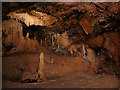
Rock formations, Kents Cavern
People love to give names to rock formations. The guide described the tiered formation at the back of this section of the cave as the 'wedding cake'. The illuminated formation to the left is known as the 'organ chamber'.
Location estimated from the cave survey map found in Proctor & Smart's 1989 report found online. Probably +/- 20m.
Image: © Stephen Craven
Taken: 25 Oct 2019
0.03 miles
8
Ashburne Villas, Wellswood
A small lane that connects Kent's Road and Kent's Lane. Image] looks the other way up it. The furthest buildings face Ilsham Road.
Image: © Derek Harper
Taken: 19 Jun 2017
0.03 miles
9
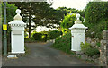
Gatepiers, Wellswood
A pair of ornate gatepier, not dissimilar to those at the nearby Kentisknowle Image], guard the entrance to Tormohun Manor.
Image: © Derek Harper
Taken: 14 Aug 2021
0.03 miles
10
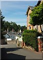
Back street, Wellswood
From the same spot as Image] and Image At the foot of the hill the main road is Ilsham Road; beyond rises St Matthias Church Road Image
Image: © Derek Harper
Taken: 11 Mar 2016
0.03 miles