IMAGES TAKEN NEAR TO
Haldon Road, TORQUAY, TQ1 2LX

Introduction

This page details the photographs taken nearby to Haldon Road, TQ1 2LX by members of the Geograph project.

The Geograph project started in 2005 with the aim of publishing, organising and preserving representative images for every square kilometre of Great Britain, Ireland and the Isle of Man.

There are currently over 7.5m images from over14,400 individuals and you can help contribute to the project by visiting https://www.geograph.org.uk

Image Map


Images are licensed for reuse under creativecommons.org/licenses/by-sa/2.0
Notes
  • Clicking on the map will re-center to the selected point.
  • The higher the marker number, the further away the image location is from the centre of the postcode.

Image Listing (63 Images Found)

Images are licensed for reuse under creativecommons.org/licenses/by-sa/2.0
  • ...
Image
Details
Distance
1
Gate pier, Haldon Road, Torquay
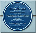
"Square-section gate piers with moulded plinths; channelled rustication and a dentil cornice below oversailing moulded caps" https://historicengland.org.uk/listing/the-list/list-entry/1208886 . On its face is a blue plaque to General Sir Herbert Charles Onslow Plumer Image The house is also listed https://historicengland.org.uk/listing/the-list/list-entry/1206777 .
Image: © Derek Harper Taken: 24 Nov 2020
0.08 miles
2
Blue plaque to Lord Plumer
Also seen in Image https://en.wikipedia.org/wiki/Herbert_Plumer,_1st_Viscount_Plumer
Image: © Derek Harper Taken: 24 Nov 2020
0.08 miles
3
Haldon Road, Torquay
Leading away from the crossroads with Oxlea Road and Higher Lincombe Road.
Image: © Derek Harper Taken: 18 May 2022
0.09 miles
4
Bench and bus stop, Higher Erith Road
At the junction with Acadia Road, the road dropping and curving on the left. The bus stop is for the number 64 service.
Image: © Derek Harper Taken: 11 Mar 2016
0.09 miles
5
Higher Lincombe Road
Running south from the junction seen in Image The road is followed by footpath TQ 118.
Image: © Derek Harper Taken: 18 May 2022
0.10 miles
6
Path arriving at Higher Lincombe Road
Footpath TQ139 climbs steps to reach the road shown in Image
Image: © Derek Harper Taken: 18 May 2022
0.10 miles
7
Higher Erith Road, Torquay
Large buildings sub-divided into flats on the north side of Lincombe Hill.
Image: © Derek Harper Taken: 11 Mar 2016
0.11 miles
8
Road junction, Lincombes
The junction of Haldon Road (foreground) with Higher Lincombe Road and Oxlea Road (opposite). A variety of mature trees, including pines and beeches, surround this focal junction in the favoured hilltop residential area. The pillar box also appears in Image
Image: © Derek Harper Taken: 7 Mar 2008
0.11 miles
9
Erith House Residential Home
This imposing building on the corner of Lower Erith Road was built in 1860/1861 to accommodate gentlewomen suffering from chest ailments. It is now a private care home for 20 residents.
Image: © Richard Dorrell Taken: 27 Mar 2010
0.11 miles
10
Pillar box and pine tree, Lincombes
This scene is at the crossroads of Oxlea Road (right) with Haldon Road and Higher Lincombe Road. The junction forms a natural focus at the top of the Lincombes.
Image: © Derek Harper Taken: 7 Mar 2008
0.11 miles
  • ...