IMAGES TAKEN NEAR TO
Meadfoot Cross, TORQUAY, TQ1 2EB
Introduction
This page details the photographs taken nearby to Meadfoot Cross, TQ1 2EB by members of the Geograph project.
The Geograph project started in 2005 with the aim of publishing, organising and preserving representative images for every square kilometre of Great Britain, Ireland and the Isle of Man.

There are currently over 7.5m images from over14,400 individuals and you can help contribute to the project by visiting https://www.geograph.org.uk
Image Map
Images are licensed for reuse under creativecommons.org/licenses/by-sa/2.0
Notes
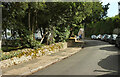
- Clicking on the map will re-center to the selected point.
- The higher the marker number, the further away the image location is from the centre of the postcode.
Image Listing (239 Images Found)
Images are licensed for reuse under creativecommons.org/licenses/by-sa/2.0
Image
Details
Distance
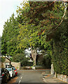
1
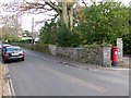
Higher Woodfield Road, Torquay
The road name is made of ceramic letters, including half-size ones for the abbreviation "r" in Higher and "d" in Road
Image: © David Smith
Taken: 5 Dec 2014
0.02 miles
2
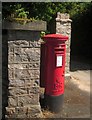
Postbox, Higher Woodfield Road
Elizabeth II postbox TQ1 7 is near the crossroads on Meadfoot Lane.
Image: © Derek Harper
Taken: 26 Jul 2013
0.03 miles
3
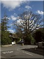
Crossroads, Meadfoot Lane, Torquay
View from Parkhill Road; Meadfoot Lane is to the left. Straight on is Higher Woodfield Road, and to the right is Meadfoot Sea Road. In the shadows at the corner is Image
Image: © Derek Harper
Taken: 21 Mar 2017
0.03 miles
4
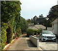
Entrance drive off Parkhill Road
To a house otherwise enclosed behind a square of roads. In the background is The Little Theatre, formerly St Mark's church, shown in Image
Image: © Derek Harper
Taken: 2 Sep 2022
0.05 miles
5
Lower Woodfield Road, Torquay
Reaching the junction shown in Image
Image: © Derek Harper
Taken: 6 Sep 2022
0.05 miles
6
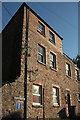
House on Vane Hill Road, Torquay
A somewhat austere three-storey building near the junction with Meadfoot Lane. Note the traditional blue tiled street name sign on the left.
Image: © Derek Harper
Taken: 31 Jul 2018
0.06 miles
7
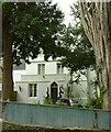
Merlewood House
"... c1840s ... Tudor Domestic style" https://historicengland.org.uk/listing/the-list/list-entry/1210065?section=official-list-entry . Formerly a hotel, now a B&B, and seen across Meadfoot Road.
Image: © Derek Harper
Taken: 6 Sep 2022
0.06 miles
8
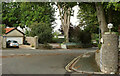
Junction on Meadfoot Road, Torquay
With Lower Woodfield Road (foreground).
Image: © Derek Harper
Taken: 6 Sep 2022
0.06 miles
9
Lower Woodfield Road, Torquay
Curving past the Lincombe Hall Hotel.
Image: © Derek Harper
Taken: 6 Sep 2022
0.07 miles
10
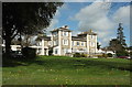
Sundial Lodge, Torquay
The building, also shown in Image] and now a residential care home, is listed and has a very full description, including detailed history (it originated in 1841) at https://www.historicengland.org.uk/listing/the-list/list-entry/1292095 . Originally named Engadine, it was briefly leased to Princess Beatrice (Queen Victoria's youngest child) and later became a preparatory school.
Image: © Derek Harper
Taken: 21 Mar 2017
0.07 miles