IMAGES TAKEN NEAR TO
Oliver Place, NEWTON ABBOT, TQ12 6TD
Introduction
This page details the photographs taken nearby to Oliver Place, TQ12 6TD by members of the Geograph project.
The Geograph project started in 2005 with the aim of publishing, organising and preserving representative images for every square kilometre of Great Britain, Ireland and the Isle of Man.

There are currently over 7.5m images from over14,400 individuals and you can help contribute to the project by visiting https://www.geograph.org.uk
Image Map
Images are licensed for reuse under creativecommons.org/licenses/by-sa/2.0
Notes
- Clicking on the map will re-center to the selected point.
- The higher the marker number, the further away the image location is from the centre of the postcode.
Image Listing (43 Images Found)
Images are licensed for reuse under creativecommons.org/licenses/by-sa/2.0
Image
Details
Distance
1
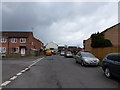
Heathfield Council Housing and Old Post Office
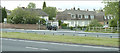
Taken from across the A38, these are the original council houses in Heathfield, built before the huge development of estate houses now to be found in the area. The building on the corner with the 4x4 in front of it was formerly the Heathfield Post Office. A new one has opened on the industrial estate close by. Before the A38 trunk road was widened, vehicles could drive straight across at this junction and take the back lane through Teigngrace and into Newton Abbot. My school bus took this very route in the early 70s.
Image: © Mike Crowe
Taken: 23 May 2005
0.12 miles

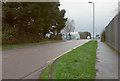
3
Battle Road, Heathfield
Looking in the other direction from Image Down the road is a red parcel postbox; a more normally-shaped pillar box is hidden behind it. There's a post office in the small shopping parade just beyond. The turning on the right is Cavalier Road.
Image: © Derek Harper
Taken: 11 Jan 2020
0.16 miles
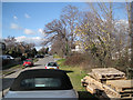
4

Heathfield : Sharps Crest
A road heads off from Old Newton Road.
Image: © Lewis Clarke
Taken: 21 Nov 2021
0.16 miles
5
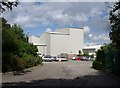
Building at British Ceramic Tiles
Formerly Candy Tiles. In the foreground is the car park for the factory shop.
Image: © Derek Harper
Taken: 21 Jul 2010
0.16 miles
6
Old Newton Road, Heathfield
Another view along Image, with the entrance to British Ceramic Tiles on the right, and Sharps Crest the road on the left.
Image: © Derek Harper
Taken: 21 Jul 2010
0.16 miles
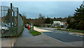
7
Corner of Musket Road and Drum Way, Heathfield
Image: © Rob Purvis
Taken: 9 Apr 2016
0.16 miles
8
Battle Road, Heathfield
Seen from the entrance to Sparkworld.
Image: © Derek Harper
Taken: 11 Jan 2020
0.16 miles
9

Heathfield : Old Newton Road
Looking along Old Newton Road.
Image: © Lewis Clarke
Taken: 21 Nov 2021
0.16 miles
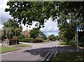
10
Southeast end of Old Newton Road, Heathfield
Looking towards Bovey Tracey with the British Ceramic Tiles works on the right and a residential road, Sharp's Crest turning off on the left (leading to Sharp's Crescent and Sharp's Close). Large yellow-green apples, looking very like 'Golden Delicious', have yet to fall from a tree in the roadside, perhaps a seedling from a discarded apple core.
Image: © Robin Stott
Taken: 19 Feb 2012
0.16 miles