IMAGES TAKEN NEAR TO
Sharps Close, NEWTON ABBOT, TQ12 6SS
Introduction
This page details the photographs taken nearby to Sharps Close, TQ12 6SS by members of the Geograph project.
The Geograph project started in 2005 with the aim of publishing, organising and preserving representative images for every square kilometre of Great Britain, Ireland and the Isle of Man.

There are currently over 7.5m images from over14,400 individuals and you can help contribute to the project by visiting https://www.geograph.org.uk
Image Map
Images are licensed for reuse under creativecommons.org/licenses/by-sa/2.0
Notes
- Clicking on the map will re-center to the selected point.
- The higher the marker number, the further away the image location is from the centre of the postcode.
Image Listing (50 Images Found)
Images are licensed for reuse under creativecommons.org/licenses/by-sa/2.0
Image
Details
Distance
1
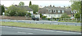
Heathfield Council Housing and Old Post Office
Taken from across the A38, these are the original council houses in Heathfield, built before the huge development of estate houses now to be found in the area. The building on the corner with the 4x4 in front of it was formerly the Heathfield Post Office. A new one has opened on the industrial estate close by. Before the A38 trunk road was widened, vehicles could drive straight across at this junction and take the back lane through Teigngrace and into Newton Abbot. My school bus took this very route in the early 70s.
Image: © Mike Crowe
Taken: 23 May 2005
0.03 miles

3
Gate, Stover Country Park
Gate into the estate from alongside the A38 dual carriageway. There is access to the other side but it doesn't look like it's been used for a long time. Travelling west on the A38 this is on the left just before the slip-road for Newton Abbot and Bovey Tracey.
Image: © Chris Allen
Taken: 28 Feb 2019
0.08 miles
6
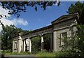
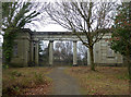
Granite Lodge, Stover
Another view of Image] https://www.historicengland.org.uk/listing/the-list/list-entry/1308943 .
Image: © Derek Harper
Taken: 7 Aug 2016
0.08 miles
7
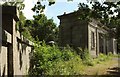
Granite Lodge, Stover
The pair of lodges, seen here along the northern flanking wall, are just beside the A38 dual carriageway. "Probably c1830 possibly by Philip Hardwick for the eleventh duke of Somerset" https://www.historicengland.org.uk/listing/the-list/list-entry/1308943 . The detailed description of this grade II* listed building at https://www.historicengland.org.uk/listing/the-list/list-entry/1308943 implies that these were stables.
Image: © Derek Harper
Taken: 7 Aug 2016
0.08 miles
8
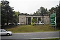
Carriage Drive and Gatehouse, Stover Estate
Image: © Gareth James
Taken: 23 Sep 2012
0.09 miles
9
Compass Caravan Park
A local caravan park adjacent to the A38 at Heathfield. Site also has facilities for maintenance and repairs as well as a sales centre. A locally owned business.
Image: © Mike Crowe
Taken: 23 May 2005
0.09 miles
10
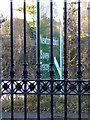
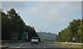
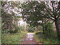
Through the Gateway
Looking towards the A38 through the gateway of Image Obviously things were very different when it was built, I took this to show how close to the A38 it is!
Image: © paul dickson
Taken: 5 Dec 2008
0.10 miles