IMAGES TAKEN NEAR TO
Bickington, NEWTON ABBOT, TQ12 6NZ
Introduction
This page details the photographs taken nearby to TQ12 6NZ by members of the Geograph project.
The Geograph project started in 2005 with the aim of publishing, organising and preserving representative images for every square kilometre of Great Britain, Ireland and the Isle of Man.

There are currently over 7.5m images from over14,400 individuals and you can help contribute to the project by visiting https://www.geograph.org.uk
Image Map
Images are licensed for reuse under creativecommons.org/licenses/by-sa/2.0
Notes
- Clicking on the map will re-center to the selected point.
- The higher the marker number, the further away the image location is from the centre of the postcode.
Image Listing (14 Images Found)
Images are licensed for reuse under creativecommons.org/licenses/by-sa/2.0
Image
Details
Distance
1
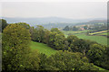
Farmland at Higher Herebere
Looking north-west from the footpath at Higher Herebere; Haytor Rocks are visible in the misty background.
Image: © Guy Wareham
Taken: 15 Sep 2008
0.05 miles
2
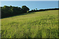
Field beside Mill Copse
The copse is on the left, sharing the steep valley side above the Lemon with this grass field seen from the junction of the green lane shown in Image] with a steep green lane up across the hill to the Kester Brook valley.
Image: © Derek Harper
Taken: 6 Jun 2022
0.15 miles
3
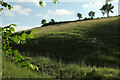
Field above Combe Park
Image: © Derek Harper
Taken: 6 Jun 2022
0.16 miles
4
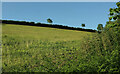
Field beside Mill Copse
Looking right from Image], with the hedge on the right of the camera bordering the steep public access route to Longstone Bridge on the Kester Brook.
Image: © Derek Harper
Taken: 6 Jun 2022
0.18 miles
5
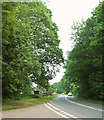
A383 near Newhouse Bridge
At the junction with a lane to Bickington, and approaching the Dartmoor Halfway Inn, recently reopened after lengthy refurbishment.
Image: © Derek Harper
Taken: 28 May 2018
0.19 miles
6
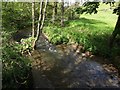
River Lemon from Newhouse Bridge
Looking downstream; Image] looks upstream.
Image: © Derek Harper
Taken: 28 May 2018
0.19 miles
7
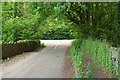
Newhouse Bridge
Crossing the River Lemon and from which Image] and Image] were taken. Ahead is the T junction with the A383.
Image: © Derek Harper
Taken: 28 May 2018
0.19 miles
8
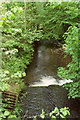
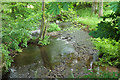
The River Lemon from bridge next to the A383
Image: © David Gearing
Taken: 16 May 2012
0.19 miles
9
River Lemon from Newhouse Bridge
Pretty much the view in Image, six years on, looking upstream.
Image: © Derek Harper
Taken: 28 May 2018
0.20 miles
10
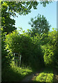
Green lane to Combe Park
High above the Kestor Brook valley.
Image: © Derek Harper
Taken: 6 Jun 2022
0.20 miles