IMAGES TAKEN NEAR TO
South Knighton, NEWTON ABBOT, TQ12 6NP
Introduction
This page details the photographs taken nearby to TQ12 6NP by members of the Geograph project.
The Geograph project started in 2005 with the aim of publishing, organising and preserving representative images for every square kilometre of Great Britain, Ireland and the Isle of Man.

There are currently over 7.5m images from over14,400 individuals and you can help contribute to the project by visiting https://www.geograph.org.uk
Image Map
Images are licensed for reuse under creativecommons.org/licenses/by-sa/2.0
Notes
- Clicking on the map will re-center to the selected point.
- The higher the marker number, the further away the image location is from the centre of the postcode.
Image Listing (11 Images Found)
Images are licensed for reuse under creativecommons.org/licenses/by-sa/2.0
Image
Details
Distance
1
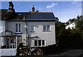
Camberley Cottage, South Knighton
Accessible only via narrow lanes, Camberley Cottage (at the time of this photograph divided into an upstairs and downstairs flat) is at the north end of South Knighton.
Image: © Stephen McKay
Taken: Unknown
0.01 miles
2
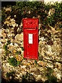
Victorian postbox, South Knighton
In an old wall by the lane junction in the hamlet.
Image: © Derek Harper
Taken: 27 Jul 2008
0.02 miles
3
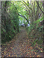
Footpath near South Knighton
Ilsington Footpath 56 heads down a green lane to cross a tributary of the River Lemon.
Image: © Derek Harper
Taken: 24 Jul 2008
0.08 miles
4
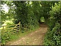
Green lane to South Knighton
Footpath Ilsington 56 from near Ingsdon Manor to South Knighton picks up this green lane with tall Devon banks west of the valley below South Knighton.
Image: © Hugh Craddock
Taken: 23 Sep 2018
0.11 miles
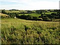
5
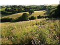
Countryside near South Knighton
Roughly a reverse view of Image, which was taken from the corner of the far field near the two buildings on the right. In between is the valley of a tributary of the Lemon. Taken from the very thistly meadow shown in that photo.
Image: © Derek Harper
Taken: 27 Jul 2008
0.14 miles
6

Butterfly near Ingsdon Manor
Small Copper, on the line of Ilsington Footpath 56 as it crosses a thistly meadow below Ingsdon Manor.
Image: © Derek Harper
Taken: 24 Jul 2008
0.15 miles
7
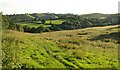
View below Ingsdon Manor
A similar view to Image, taken from the corner of the meadow and looking more to the right.
Image: © Derek Harper
Taken: 27 Jul 2008
0.16 miles
8
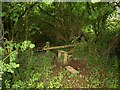
Dodgy stile near South Knighton
With thick mud and chunks of railway sleeper as scattered stepping stones round about, this stile has a slightly loose step, so the operation of following Ilsington Footpath 56 requires a good deal of concentration at this point. The path, which changes from a field path to a green lane through trees here, is about to cross a tributary of the River Lemon.
Image: © Derek Harper
Taken: 24 Jul 2008
0.16 miles
9
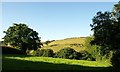
Valley near South Knighton
Taken from roughly the same spot as Image, looking to the left across a field that slopes down to a tributary of the Lemon. Behind rises a southern spur of Ingsdon Hill.
Image: © Derek Harper
Taken: 27 Jul 2008
0.22 miles
10
Valley near South Knighton
Image: © Derek Harper
Taken: 27 Jul 2008
0.23 miles