IMAGES TAKEN NEAR TO
Bickington, NEWTON ABBOT, TQ12 6LH
Introduction
This page details the photographs taken nearby to TQ12 6LH by members of the Geograph project.
The Geograph project started in 2005 with the aim of publishing, organising and preserving representative images for every square kilometre of Great Britain, Ireland and the Isle of Man.

There are currently over 7.5m images from over14,400 individuals and you can help contribute to the project by visiting https://www.geograph.org.uk
Image Map
Images are licensed for reuse under creativecommons.org/licenses/by-sa/2.0
Notes
- Clicking on the map will re-center to the selected point.
- The higher the marker number, the further away the image location is from the centre of the postcode.
Image Listing (8 Images Found)
Images are licensed for reuse under creativecommons.org/licenses/by-sa/2.0
Image
Details
Distance
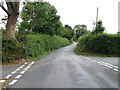
1
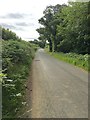
Minor road
Heading towards the A38 and Newton Abbot.
Image: © jeff collins
Taken: 7 Jul 2020
0.14 miles
2
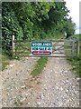
Private track to Goodstone Woods
The Gate is locked. Within the Dartmoor National Park.
Image: © jeff collins
Taken: 7 Jul 2020
0.19 miles
3
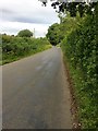
Minor road heading towards Stormsdown
Just ahead is Hooks Cross.
Image: © jeff collins
Taken: 7 Jul 2020
0.22 miles
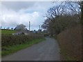
4
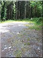
HGV turning bay
Used by the timber lorries to turn around after loading.
Image: © jeff collins
Taken: 7 Jul 2020
0.23 miles
6
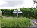
Hooks Cross
Sign post says Hook Cross, a variation in spelling or an error
Image: © Alex McGregor
Taken: 4 Aug 2014
0.25 miles
7
Hooks Cross from the west
The signpost at the crossroads is labelled Hook Cross, but the OS map uses Hooks
Image: © David Smith
Taken: 25 Mar 2014
0.25 miles
8
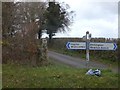
Signpost and stone cross at Hook Cross
The OS map labels the crossroads "Hooks Cross" which makes more sense as the wood is Hooks Plantation
Image: © David Smith
Taken: 25 Mar 2014
0.25 miles