IMAGES TAKEN NEAR TO
Lynwood, NEWTON ABBOT, TQ12 6FQ
Introduction
This page details the photographs taken nearby to Lynwood, TQ12 6FQ by members of the Geograph project.
The Geograph project started in 2005 with the aim of publishing, organising and preserving representative images for every square kilometre of Great Britain, Ireland and the Isle of Man.

There are currently over 7.5m images from over14,400 individuals and you can help contribute to the project by visiting https://www.geograph.org.uk
Image Map
Images are licensed for reuse under creativecommons.org/licenses/by-sa/2.0
Notes
- Clicking on the map will re-center to the selected point.
- The higher the marker number, the further away the image location is from the centre of the postcode.
Image Listing (23 Images Found)
Images are licensed for reuse under creativecommons.org/licenses/by-sa/2.0
Image
Details
Distance
1
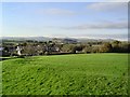
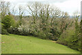
East Ogwell's village green - Devon
This large (and well used) village green has a splendid view over Dartmoor and the surrounding countryside.
Image: © Richard Knights
Taken: 20 Nov 2005
0.12 miles
2
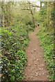
Footpath, Powsey Moor
Looking the other way from Image] as Ogwell footpath 1 climbs towards East Ogwell. Lesser celandines, dog's mercury, ramsons and ivy provide ground cover.
Image: © Derek Harper
Taken: 13 Apr 2021
0.16 miles
3
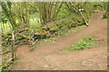
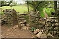
Path junction, Emblett Hill
The curving kissing gate is on Ogwell footpath 1 and can just be made out beyond the walker in Image The path continues steeply to the right behind the camera. Ahead right is Ogwell footpath 2, leading to Ogwell Road.
Image: © Derek Harper
Taken: 13 Apr 2021
0.16 miles
4
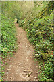
Footpath, Powsey Moor
Ogwell footpath 1 descends into the Lemon valley.
Image: © Derek Harper
Taken: 13 Apr 2021
0.16 miles
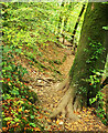
5
Field on Emblett Hill
Ogwell footpath 1 drops to the corner of the field and enters woodland to reach the junction shown in Image
Image: © Derek Harper
Taken: 13 Apr 2021
0.17 miles
6

Mossy stems, Powsey Moor
These young sycamore stems have mossy sheaths, like those in Image
Image: © Derek Harper
Taken: 13 Apr 2021
0.20 miles
7
Stile, East Hill
Ogwell footpath 1 turns right here, crossing the stile to head towards East Ogwell.
Image: © Derek Harper
Taken: 13 Apr 2021
0.21 miles
8
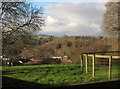
Meadow Halt and Lang's Copse
A view from Old Totnes Road to part of the housing estate at East Ogwell, with houses at Meadow Halt backed by Lang's copse, and Berry Wood behind them across the Lemon valley.
Image: © Derek Harper
Taken: 1 Dec 2012
0.21 miles
9
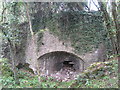
Lime Kiln - Ransley Quarry - East Ogwell
The old quarry had a lime kiln so that some of the limestone from the quarry could be burnt to produce quick lime for spreading on the fields to help neutrialise the acid soil and so improve its productivity. It also had various uses in the building industry like providing the lime to add to mortar to make it more workable.
Typically the kiln took a day to load, three days to fire, two days to cool and a day to unload, so a one-week turnaround was normal. By all accounts the process resulted in a rather foul smell and acidic fumes making the area around the limekiln rather hazardous and unpleasant.Image
Image: © Colin Vosper
Taken: 21 Apr 2012
0.22 miles
10
Footpath, Powsey Moor
Ogwell footpath 3 makes its way along the steep southern valley side south of the Lemon.
Image: © Derek Harper
Taken: 18 Oct 2020
0.22 miles