IMAGES TAKEN NEAR TO
Larksmead Way, NEWTON ABBOT, TQ12 6FE
Introduction
This page details the photographs taken nearby to Larksmead Way, TQ12 6FE by members of the Geograph project.
The Geograph project started in 2005 with the aim of publishing, organising and preserving representative images for every square kilometre of Great Britain, Ireland and the Isle of Man.

There are currently over 7.5m images from over14,400 individuals and you can help contribute to the project by visiting https://www.geograph.org.uk
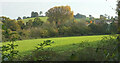
Image Map
Images are licensed for reuse under creativecommons.org/licenses/by-sa/2.0
Notes
- Clicking on the map will re-center to the selected point.
- The higher the marker number, the further away the image location is from the centre of the postcode.
Image Listing (48 Images Found)
Images are licensed for reuse under creativecommons.org/licenses/by-sa/2.0
Image
Details
Distance
1
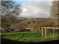
Meadow Halt and Lang's Copse
A view from Old Totnes Road to part of the housing estate at East Ogwell, with houses at Meadow Halt backed by Lang's copse, and Berry Wood behind them across the Lemon valley.
Image: © Derek Harper
Taken: 1 Dec 2012
0.07 miles
2
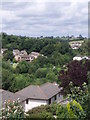
East Ogwell flood defences
The valley sides of this small stream have been used for housing. The development being built in the 1980s. The stream itself has been culverted through much of the development. The large green bank in the centre of the picture is part of the flood defences on the stream (a tributary to the river Lemon) which form part of the wider flood management system in the area. Highweek Church is visible on the prominent spur on the horizon.
Image: © Gwen and James Anderson
Taken: 22 Jul 2007
0.09 miles
3

Mackerel sky over Lemon valley
A view from Bradley Road. The tree on the left is across the A381 by the top of the path shown in Image
Image: © Derek Harper
Taken: 12 Jul 2022
0.11 miles
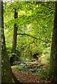
4
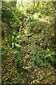
Stream, Lang's Copse
A tributary of the Lemon seen looking upstream from the footbridge carrying Newton Abbot footpath 26 across it to become Ogwell footpath 4, the stream being a parish boundary.
Image: © Derek Harper
Taken: 18 Oct 2020
0.13 miles
5
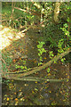
Stream, Lang's Copse
Looking downstream from the footbridge from which Image] looks upstream.
Image: © Derek Harper
Taken: 18 Oct 2020
0.14 miles
6
Field by Lang's Copse
From Ogwell footpath 4. The houses on the right are on Beverley Way.
Image: © Derek Harper
Taken: 18 Oct 2020
0.14 miles
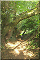
7
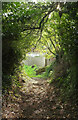
Footpath to Totnes Road
Newton Abbot footpath 26 emerges from Lang's Copse.
Image: © Derek Harper
Taken: 18 Oct 2020
0.15 miles
8
River Lemon in Lang's Copse
Looking upstream from Ogwell footpath 4.
Image: © Derek Harper
Taken: 18 Oct 2020
0.15 miles
9
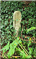
Electrical cable marker
On Newton Abbot footpath 26 shown in Image
Image: © Derek Harper
Taken: 13 Apr 2021
0.15 miles
10
Footpath to the Lemon valley
Looking in the other direction from Image] down Newton Abbot footpath 26 as it reaches a left bend.
Image: © Derek Harper
Taken: 18 Oct 2020
0.15 miles