IMAGES TAKEN NEAR TO
Larksmead Way, NEWTON ABBOT, TQ12 6BT
Introduction
This page details the photographs taken nearby to Larksmead Way, TQ12 6BT by members of the Geograph project.
The Geograph project started in 2005 with the aim of publishing, organising and preserving representative images for every square kilometre of Great Britain, Ireland and the Isle of Man.

There are currently over 7.5m images from over14,400 individuals and you can help contribute to the project by visiting https://www.geograph.org.uk
Image Map
Images are licensed for reuse under creativecommons.org/licenses/by-sa/2.0
Notes
- Clicking on the map will re-center to the selected point.
- The higher the marker number, the further away the image location is from the centre of the postcode.
Image Listing (31 Images Found)
Images are licensed for reuse under creativecommons.org/licenses/by-sa/2.0
Image
Details
Distance
1
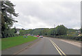
A381 approaches junction with Ogwell Road
Image: © Stuart Logan
Taken: 4 Oct 2013
0.06 miles
2
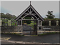
Ogwell Cross Cemetery
The pedestrian entrance to the cemetery from the A381.
Image: © Guy Wareham
Taken: 18 Apr 2020
0.06 miles
3
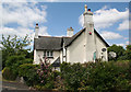
Wolborough Toll House by Old Totnes Road
Toll House by Old Totnes Road at its junction with the A381, in parish of Newton Abbot (Teignbridge District), Wolborough Lodge at Ogwell Cross.
Devon & Dartmoor HER.
HER Number: MDV52532 https://www.heritagegateway.org.uk/Gateway/Results_Single.aspx?uid=MDV52532&resourceID=104
Surveyed
Milestone Society National ID: DV.NEA02
Image: © Alan Rosevear
Taken: 25 Jun 2010
0.06 miles
4
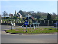
Roundabout at East Ogwell
The cemetery and chapel can be seen in the background.
Image: © Ruth Sharville
Taken: 25 Mar 2012
0.06 miles
5
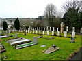
War graves
A dignified row of stones at Newton Abbot cemetery.
Image: © Jonathan Billinger
Taken: 2 Feb 2010
0.09 miles
6
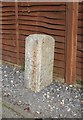
Boundary Marker by Ogwell Road, Ogwell
Parish Boundary Marker by the UC road, in parish of Ogwell (Teignbridge District), 25m West of Reynell Road, East Ogwell, just West of Queen Anne's Copse, beside path, on gravel next to garden fence. Set up in the 1980s.
Inscription reads:-
: OGL : : NA :
(Ogwell and Newton Abbott)
Devon & Dartmoor HER.
HER Number: MDV80665 https://www.heritagegateway.org.uk/Gateway/Results_Single.aspx?uid=MDV80665&resourceID=104
Surveyed
Milestone Society National ID: DV_TNCH06pb
Image: © Alan Rosevear
Taken: 19 Mar 2012
0.10 miles
7

Cemetery near Newton Abbot
This attractive looking chapel is situated in the cemetery on the outskirts of Newton Abbot, near Wolborough.
Image: © Mike Crowe
Taken: 4 Jun 2005
0.10 miles
8
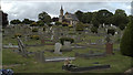
Cemetery View
This is a wider angle view of the cemetery seen in the accompanying picture.
Image: © Mike Crowe
Taken: 4 Jun 2005
0.10 miles
9

Railings, pillars and wall, Newton Abbot cemetery
Stepping down the hill beside the lane between Abbotskerswell and Wolborough.
Image: © Derek Harper
Taken: 1 Dec 2012
0.10 miles
10

Oak trees, Old Totnes Road
With the nearer tree's trunk thoroughly covered in ivy.
Image: © Derek Harper
Taken: 1 Dec 2012
0.10 miles