IMAGES TAKEN NEAR TO
Ford Road, NEWTON ABBOT, TQ12 5YQ
Introduction
This page details the photographs taken nearby to Ford Road, TQ12 5YQ by members of the Geograph project.
The Geograph project started in 2005 with the aim of publishing, organising and preserving representative images for every square kilometre of Great Britain, Ireland and the Isle of Man.

There are currently over 7.5m images from over14,400 individuals and you can help contribute to the project by visiting https://www.geograph.org.uk
Image Map
Images are licensed for reuse under creativecommons.org/licenses/by-sa/2.0
Notes
- Clicking on the map will re-center to the selected point.
- The higher the marker number, the further away the image location is from the centre of the postcode.
Image Listing (131 Images Found)
Images are licensed for reuse under creativecommons.org/licenses/by-sa/2.0
Image
Details
Distance
1
Orange Way in Devon and Torbay (104)
The way to go is up Ford Road.
Image: © Shazz
Taken: 20 Oct 2011
0.04 miles
2

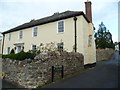
Abbotsford, Abbotskerswell
"Circa late C18/early C19 re-modelling of probably C17 house with C18 and C19 rear wings ... " https://historicengland.org.uk/listing/the-list/list-entry/1164125?section=official-listing . Also visible in Image
Image: © Derek Harper
Taken: 1 Jun 2021
0.04 miles
4

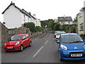
Listed buildings, Abbotskerswell
On the left is Yeoman's Cottage https://historicengland.org.uk/listing/the-list/list-entry/1097357?section=official-listing ; across the junction with Ford Road is Abbotsford https://historicengland.org.uk/listing/the-list/list-entry/1164125?section=official-listing : "formerly farmhouse. Circa late C18/early C19 re-modelling of probably C17 house with C18 and C19 rear wings ..."
Image: © Derek Harper
Taken: 1 Jun 2021
0.05 miles
6

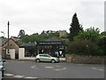
Monk's Thatch, Abbotskerswell
"Farmhouse. Late C16 with C17 alterations, C18 wing ... This house preserves some interesting internal features and its traditional facade in a very prominent roadside position contribute greatly to the character of the main street" https://historicengland.org.uk/listing/the-list/list-entry/1334117?section=official-listing .
Image: © Derek Harper
Taken: 1 Jun 2021
0.06 miles
7
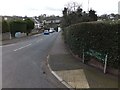
Ford Road in Abbotskerswell
A residential street in the village
Image: © David Smith
Taken: 17 Feb 2012
0.06 miles
8
Abbotskerswell
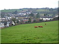
Looking west across the north side of the village from Stonemans Hill.
Image: © Derek Harper
Taken: 26 Mar 2006
0.07 miles
9
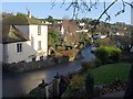
Main Street, Abbotskerswell
From Abbotskerswell Footpath 4, which climbs from the junction with Odle Hill just to the left. The street winds down to become Slade Lane.
Image: © Derek Harper
Taken: 6 Dec 2009
0.08 miles
10
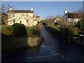
Odle Hill, Abbotskerswell
Like Image, a view from Abbotskerswell Footpath 4, perched above the junction with Main Street. Odle Hill Cottage, on the right, is listed https://historicengland.org.uk/listing/the-list/list-entry/1317918?section=official-listing .
Image: © Derek Harper
Taken: 6 Dec 2009
0.09 miles