IMAGES TAKEN NEAR TO
Totnes Road, NEWTON ABBOT, TQ12 5TD
Introduction
This page details the photographs taken nearby to Totnes Road, TQ12 5TD by members of the Geograph project.
The Geograph project started in 2005 with the aim of publishing, organising and preserving representative images for every square kilometre of Great Britain, Ireland and the Isle of Man.

There are currently over 7.5m images from over14,400 individuals and you can help contribute to the project by visiting https://www.geograph.org.uk
Image Map
Images are licensed for reuse under creativecommons.org/licenses/by-sa/2.0
Notes
- Clicking on the map will re-center to the selected point.
- The higher the marker number, the further away the image location is from the centre of the postcode.
Image Listing (41 Images Found)
Images are licensed for reuse under creativecommons.org/licenses/by-sa/2.0
Image
Details
Distance
1
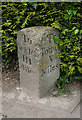
Old Milestone by the A381, Totnes Road, Ipplepen Parish
Carved stone post by the A381, in parish of IPPLEPEN (TEIGNBRIDGE District), 300m South of Causeway Cross and 50m North West of West Country Motors, on pavement parking area by property under hedge, on the North West side of the road. Newton faces (Roman), erected by the Totnes & Bridgetown-Pomeroy turnpike trust in the 18th century.
Inscription reads:- : To / Newton / III / Miles : : To / Totnes / V / Miles :
Carved benchmark on top.
Milestone Society National ID: DV_TNCH05.
Image: © Alan Rosevear
Taken: 3 May 2011
0.05 miles
2
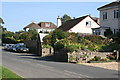
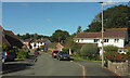
East Street, Ipplepen
Houses in a variety of shapes line this road through the eastern side of Ipplepen.
Image: © Tony Atkin
Taken: 27 Sep 2008
0.10 miles
3
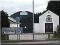
Causeway Cross on A381
The junction gives access to Ipplepen, just off the A381. At Causeway Cross the building on the right of the gates was - presumably - once a stable.
Image: © David Smith
Taken: 17 Feb 2012
0.12 miles
4
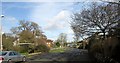
Foredown Road, Ipplepen
On the left is a bus shelter where I, well, sheltered for a while from torrential rain on Friday, 30 May, 2008 before resuming a very wet walk from Torquay to Broadhempston.
Image: © Derek Harper
Taken: 23 Feb 2017
0.13 miles
5
Stile on path to Ipplepen
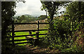
Just through the trees from Image Ipplepen footpath 6 is a mere 177 metres according to http://www.rowmaps.com/ , ending at the A381 across a field. The wooded Denbury Down can be glimpsed above the wall.
Image: © Derek Harper
Taken: 8 Aug 2021
0.13 miles
6
Dorneyfield Drive East
From its junction with East Street.
Image: © Derek Harper
Taken: 20 Sep 2021
0.13 miles
7
Path to Ipplepen
Taken just beyond the stile shown in Image Ipplepen footpath 6 runs beside the wall to another stile at the A381. Dark in the distance is Ipplepen's church tower.
Image: © Derek Harper
Taken: 8 Aug 2021
0.14 miles
8
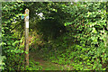
Footpath signpost near Ipplepen
Image: © Derek Harper
Taken: 8 Aug 2021
0.14 miles
9

Lane to Dainton Elms Cross
Looking right from Image
Image: © Derek Harper
Taken: 8 Aug 2021
0.14 miles
10
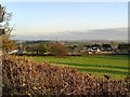
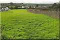
Near Park Hill - South Devon
The houses down below surround the busy A381 which links Totnes and Newton Abbot.
Image: © Richard Knights
Taken: 20 Nov 2005
0.14 miles