IMAGES TAKEN NEAR TO
Newhayes, NEWTON ABBOT, TQ12 5SD
Introduction
This page details the photographs taken nearby to Newhayes, TQ12 5SD by members of the Geograph project.
The Geograph project started in 2005 with the aim of publishing, organising and preserving representative images for every square kilometre of Great Britain, Ireland and the Isle of Man.

There are currently over 7.5m images from over14,400 individuals and you can help contribute to the project by visiting https://www.geograph.org.uk
Image Map
Images are licensed for reuse under creativecommons.org/licenses/by-sa/2.0
Notes
- Clicking on the map will re-center to the selected point.
- The higher the marker number, the further away the image location is from the centre of the postcode.
Image Listing (135 Images Found)
Images are licensed for reuse under creativecommons.org/licenses/by-sa/2.0
Image
Details
Distance
2
Public conveniences, Clampitt Lane, Ipplepen
Image: © Robin Stott
Taken: 7 Jul 2013
0.04 miles
3
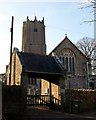
Lychgate and church, Ipplepen
See also Image The lychgate, with its decorated ridge tiles, may be partly C17 http://www.imagesofengland.org.uk/Details/Default.aspx?id=84831&mode=adv .
Image: © Derek Harper
Taken: 18 Dec 2009
0.04 miles
4
![Parish church [5]](https://s3.geograph.org.uk/geophotos/06/19/97/6199779_8ec8ffcd_120x120.jpg)
Parish church [5]
The lychgate into the churchyard from Church Path. Erected in the 17th century and remodelled in the 19th century the gate is listed, grade II, with details at: https://historicengland.org.uk/listing/the-list/list-entry/1097278
The church of St Andrew is 15th century with some earlier fabric in the chancel. Restored in 1898. Built in the Perpendicular style with a tower some 91½ feet high, the church is very visible for many miles around. Described by English Heritage as 'a well-preserved 15th century church with some interesting earlier fragments and good quality interior fittings. Listed, grade I, with details at: https://historicengland.org.uk/listing/the-list/list-entry/1334135
Image: © Michael Dibb
Taken: 30 May 2019
0.04 miles
5
![Ipplepen buildings [3]](https://s0.geograph.org.uk/geophotos/06/19/97/6199780_79623d77_120x120.jpg)
Ipplepen buildings [3]
Number 2 (White Cottage) and number 3 Church Cottages were originally once house. Probably built in the early 17th century and divided into two probably in the 19th century. Listed, grade II, with details at: https://historicengland.org.uk/listing/the-list/list-entry/1097280
Image: © Michael Dibb
Taken: 30 May 2019
0.04 miles
6
Old building, Ipplepen
Between The Wellington Image and Church Path, is this old building.
Image: © Paul Hutchinson
Taken: 24 Dec 2008
0.05 miles
7
![Ipplepen buildings [4]](https://s1.geograph.org.uk/geophotos/06/19/97/6199781_3637982a_120x120.jpg)
Ipplepen buildings [4]
The Old House was built in the 17th century or possibly earlier with 20th century alterations and extensions. Possibly at one time almshouses. Listed, grade II, with details at: https://historicengland.org.uk/listing/the-list/list-entry/1097284
Image: © Michael Dibb
Taken: 30 May 2019
0.05 miles
8

Ipplepen Health Centre, Silver Street, Ipplepen
Image: © Robin Stott
Taken: 7 Jul 2013
0.05 miles
9
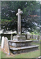
Old cross in Ipplepen churchyard
Old cross in the churchyard, in parish of Ipplepen (Teignbridge District).
Image: © Alan Rosevear
Taken: 15 Jul 2010
0.05 miles
10
![Parish church [4]](https://s2.geograph.org.uk/geophotos/06/19/97/6199778_a6d7a555_120x120.jpg)
Parish church [4]
The churchyard cross is 15th century with the head and arms restored. A Scheduled Ancient Monument, there are details at: https://historicengland.org.uk/listing/the-list/list-entry/1003823
The churchyard contains several listed tombs and headstones.
The church of St Andrew is 15th century with some earlier fabric in the chancel. Restored in 1898. Built in the Perpendicular style with a tower some 91½ feet high, the church is very visible for many miles around. Described by English Heritage as 'a well-preserved 15th century church with some interesting earlier fragments and good quality interior fittings. Listed, grade I, with details at: https://historicengland.org.uk/listing/the-list/list-entry/1334135
Image: © Michael Dibb
Taken: 30 May 2019
0.05 miles