IMAGES TAKEN NEAR TO
Grange Close, NEWTON ABBOT, TQ12 5RX
Introduction
This page details the photographs taken nearby to Grange Close, TQ12 5RX by members of the Geograph project.
The Geograph project started in 2005 with the aim of publishing, organising and preserving representative images for every square kilometre of Great Britain, Ireland and the Isle of Man.

There are currently over 7.5m images from over14,400 individuals and you can help contribute to the project by visiting https://www.geograph.org.uk
Image Map
Images are licensed for reuse under creativecommons.org/licenses/by-sa/2.0
Notes
- Clicking on the map will re-center to the selected point.
- The higher the marker number, the further away the image location is from the centre of the postcode.
Image Listing (19 Images Found)
Images are licensed for reuse under creativecommons.org/licenses/by-sa/2.0
Image
Details
Distance
1
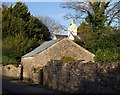
Barn, North Street, Ipplepen
An attractive little stone barn set into the wall on the east side of North Street, beside the stream at the foot of the hill.
Image: © Derek Harper
Taken: 18 Dec 2009
0.16 miles
2
![Ipplepen buildings [11]](https://s2.geograph.org.uk/geophotos/06/20/14/6201454_2a7f6da8_120x120.jpg)
Ipplepen buildings [11]
This former farmhouse is now three cottages - numbers 19, 21 and 23 North Street. Probably built in the late 16th or early 17th century and probably divided in the 19th century. Some original internal features survive. Listed, grade II, with details at: https://historicengland.org.uk/listing/the-list/list-entry/1097287
Image: © Michael Dibb
Taken: 30 May 2019
0.17 miles
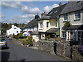
4
North Street
Looking downhill from the junction with Fore Street and Bridge Street.
Image: © Tony Atkin
Taken: 27 Sep 2008
0.19 miles
5
![Ipplepen buildings [10]](https://s2.geograph.org.uk/geophotos/06/19/98/6199806_c4d57203_120x120.jpg)
Ipplepen buildings [10]
Lawn Cottage (front right) is probably 18th century and is listed, grade II, with details at: https://historicengland.org.uk/listing/the-list/list-entry/1334158
Number 15 North Street (rear left) is probably late 16th century with later additions. There are some original internal features. Listed, grade II, with details at: https://historicengland.org.uk/listing/the-list/list-entry/1097286
Image: © Michael Dibb
Taken: 30 May 2019
0.21 miles
6
![Ipplepen buildings [12]](https://s3.geograph.org.uk/geophotos/06/20/14/6201455_ea7d14d5_120x120.jpg)
Ipplepen buildings [12]
Unusually the end house in this row in North Street is the only one that has remained thatched.
Image: © Michael Dibb
Taken: 30 May 2019
0.22 miles
7
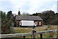
Disused church property, Ipplepen
Almost obscured by the panel lorry, this disused church property is at the eastern end of Bridge Street, Ipplepen.
Image: © Paul Hutchinson
Taken: 24 Dec 2008
0.22 miles
8
![Ipplepen buildings [9]](https://s3.geograph.org.uk/geophotos/06/19/98/6199803_30415bb4_120x120.jpg)
Ipplepen buildings [9]
Numbers 5 and 7 North Street were originally one 17th century (or earlier) farmhouse which was divided into two and the outshuts added probably in the 19th century. Listed, grade II, with the details at: https://historicengland.org.uk/listing/the-list/list-entry/1164794
Image: © Michael Dibb
Taken: 30 May 2019
0.23 miles
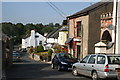
9
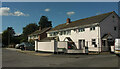
Brook Road, Ipplepen
A cul-de-sac off Dornafield Road.
Image: © Derek Harper
Taken: 20 Sep 2021
0.23 miles
10
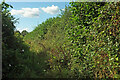
Overgrown path, Ipplepen
Leading beside the field shown in Image] to another field; not a right of way.
Image: © Derek Harper
Taken: 20 Sep 2021
0.24 miles