IMAGES TAKEN NEAR TO
South View, NEWTON ABBOT, TQ12 5PA
Introduction
This page details the photographs taken nearby to South View, TQ12 5PA by members of the Geograph project.
The Geograph project started in 2005 with the aim of publishing, organising and preserving representative images for every square kilometre of Great Britain, Ireland and the Isle of Man.

There are currently over 7.5m images from over14,400 individuals and you can help contribute to the project by visiting https://www.geograph.org.uk
Image Map
Images are licensed for reuse under creativecommons.org/licenses/by-sa/2.0
Notes
- Clicking on the map will re-center to the selected point.
- The higher the marker number, the further away the image location is from the centre of the postcode.
Image Listing (141 Images Found)
Images are licensed for reuse under creativecommons.org/licenses/by-sa/2.0
Image
Details
Distance
1
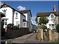
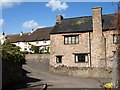
South View, Abbotskerswell
A small cul-de-sac leading off Slade Lane between Victorian houses and opposite Image I am sure that one of the cottages on South View was a pub about 35 years ago.
Image: © Derek Harper
Taken: 1 May 2008
0.02 miles
2
Orange Way in Devon and Torbay (103)
The Way uses Slade Lane in Abbotskerswell.
Image: © Shazz
Taken: 20 Oct 2011
0.02 miles
3

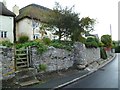
Abbotskerswell Street Scene
Some nice old houses here but nobody on the street.
Image: © Tony Atkin
Taken: 23 Apr 2009
0.03 miles
4
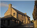
Church house, Abbotskerswell
Also shown in http://www.geograph.org.uk/search.php?i=38695575 . The building is described at http://www.britishlistedbuildings.co.uk/en-84727-church-house-abbotskerswell-devon .
Image: © Derek Harper
Taken: 18 Dec 2012
0.03 miles
5
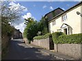
Slade Lane, Abbotskerswell
Image: © Derek Harper
Taken: 1 May 2008
0.03 miles
6

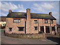
Church house, Abbotskerswell
Also shown at http://www.geograph.org.uk/search.php?i=150701321 . https://historicengland.org.uk/listing/the-list/list-entry/1097318?section=official-listing : "Mid C16 restored in 1913-14 ... Documentary evidence relates that on 24th November 1542 the Abbot of Sherbourne gave to "our parish Church of Kerswell Abbot" a parcel of land on which is built the church house. Despite the C20 restoration, this church house remains virtually unaltered in form, preserving some good quality internal features, with more possibly concealed, and is a good example of its kind occupying a very prominent position in the village centre".
Image: © Derek Harper
Taken: 1 Jun 2021
0.03 miles
7
Church House, Abbotskerswell
A restored sixteenth-century building in the heart of the village; note the arched lights in the wooded window-frames https://historicengland.org.uk/listing/the-list/list-entry/1097318?section=official-listing . The Church house is an important feature in Devon's villages - some 50 or 60 still exist. They were an early form of village hall, dating from the Reformation, often close to the churchyard (this one is some 70 metres away, but thereby links the church to the village centre). Many have become pubs.
The village, with extensive housing estates for commuters to the nearby towns, has a pretty core, as exemplified by the thatched cottages on the main street. Town Farmhouse, in the background, is described at https://historicengland.org.uk/listing/the-list/list-entry/1097317?section=official-listing . Building work is taking place on the right.
Image: © Derek Harper
Taken: 1 May 2008
0.03 miles
8
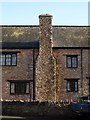
Stack, Church House, Abbotskerswell
The lateral stack on the southwest side of Image The building is described at http://www.imagesofengland.org.uk/Details/Default.aspx?id=84727&mode=adv .
Image: © Derek Harper
Taken: 6 Dec 2009
0.03 miles
10
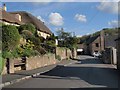
Slade Lane, Abbotskerswell
The main village street. On the right some 50 metres ahead is Image, which also shows the thatched cottages on the left.
Image: © Derek Harper
Taken: 1 May 2008
0.03 miles