IMAGES TAKEN NEAR TO
Edginswell Lane, NEWTON ABBOT, TQ12 5LX
Introduction
This page details the photographs taken nearby to Edginswell Lane, TQ12 5LX by members of the Geograph project.
The Geograph project started in 2005 with the aim of publishing, organising and preserving representative images for every square kilometre of Great Britain, Ireland and the Isle of Man.

There are currently over 7.5m images from over14,400 individuals and you can help contribute to the project by visiting https://www.geograph.org.uk
Image Map
Images are licensed for reuse under creativecommons.org/licenses/by-sa/2.0
Notes
- Clicking on the map will re-center to the selected point.
- The higher the marker number, the further away the image location is from the centre of the postcode.
Image Listing (105 Images Found)
Images are licensed for reuse under creativecommons.org/licenses/by-sa/2.0
Image
Details
Distance
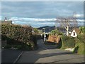
1
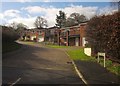
Hayley Park, Kingskerswell
A modern cul-de-sac of six detached houses off what was, until quite recently, a country lane: Edginswell Lane.
Image: © Derek Harper
Taken: 14 Feb 2013
0.02 miles
2
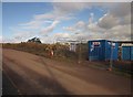
Site buildings on Edginswell Lane
In association with preparatory work on the new Kingskerswell bypass. On the left is the hedge clearance shown in Image
Image: © Derek Harper
Taken: 14 Feb 2013
0.05 miles
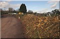
3
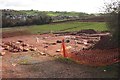
Excavation by Edginswell Lane
The foundations of what was probably a medieval barn were first detected in 2003; they have been uncovered during preparatory work for the new bypass which will cross this field. The accompanying notice explains that "numerous fragments of ox shoe" were found along the trackway between the building (possibly C13) and Edginswell Lane.
The buildings in the background are in the southern part of Kingskerswell. Trees have been cleared from the field boundary across on the right.
Image: © Derek Harper
Taken: 14 Feb 2013
0.05 miles
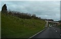
4
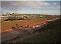
South Devon Link Road
The road being constructed through a cutting alongside Edginswell Lane at Huxnor. In the background is the southern part of Kingskerswell.
Image: © Derek Harper
Taken: 16 Feb 2015
0.05 miles
5
![Kingkerswell bypass [2]](https://s0.geograph.org.uk/geophotos/06/19/48/6194824_bc1d9452_120x120.jpg)
Kingkerswell bypass [2]
The South Devon Link Road, A380, seen from the bridge carrying Huxnor Road. This view is looking towards Torquay.
Plans to alleviate traffic on the A380 road that ran through Kingskerswell had been in place since the 1950s but after being postponed, cancelled and reinstated, planning permission was granted in August 2005 with the main construction work due to start in Summer 2010 for completion in 2013. Finally in November 2011 the government awarded £74.6 million towards the cost of the bypass and the county council stated that it hoped that construction could start in October 2012 with completion in December 2015. The bypass was opened to traffic on 15 December 2015. Views of the old route through Kingskerswell are at Image and Image
Image: © Michael Dibb
Taken: 27 May 2019
0.06 miles
6
Narrow stretch of Huxnor Road with marked footway
Image: © David Smith
Taken: 25 Feb 2012
0.06 miles
7
Young trees to reduce noise when fully grown
Image: © John C
Taken: 16 Apr 2018
0.06 miles
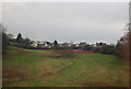
8
Hedge removal, Edginswell Lane
The hedgebank by the junction with Yon Street covered with the splintered remains of the hedge, cleared in preparation for work on the new bypass.
Image: © Derek Harper
Taken: 14 Feb 2013
0.07 miles
10
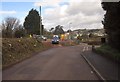
Junction at Huxnor
Huxnor road meets Yon Street (ahead) and Edginswell Lane at the site of the new bypass, which will cross Yon Street just beyond the junction. On the left behind the barriers is the site of The Cott, demolished as part of the preparation.
Image: © Derek Harper
Taken: 14 Feb 2013
0.08 miles