IMAGES TAKEN NEAR TO
Old Newton Road, NEWTON ABBOT, TQ12 5LB
Introduction
This page details the photographs taken nearby to Old Newton Road, TQ12 5LB by members of the Geograph project.
The Geograph project started in 2005 with the aim of publishing, organising and preserving representative images for every square kilometre of Great Britain, Ireland and the Isle of Man.

There are currently over 7.5m images from over14,400 individuals and you can help contribute to the project by visiting https://www.geograph.org.uk
Image Map
Images are licensed for reuse under creativecommons.org/licenses/by-sa/2.0
Notes
- Clicking on the map will re-center to the selected point.
- The higher the marker number, the further away the image location is from the centre of the postcode.
Image Listing (62 Images Found)
Images are licensed for reuse under creativecommons.org/licenses/by-sa/2.0
Image
Details
Distance
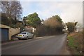
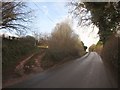
1
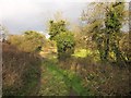
Track by Old Newton Road
Leading to a gate into a meadow from the stretch of road shown in Image] opposite Woodlands.
Image: © Derek Harper
Taken: 21 Jan 2013
0.03 miles
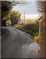
2
Preparing for the new road
A bypass will be shortly built here.
Image: © N Chadwick
Taken: 4 Jan 2013
0.04 miles
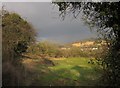
3
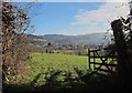
Through a gateway, Old Newton Road
A view that shouldn't change when the new link road bypasses Kingskerswell, as the route lies behind the camera.
Image: © Derek Harper
Taken: 18 Feb 2015
0.04 miles
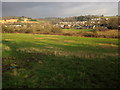
4
Field by Old Newton Road
A closer look at the scene in Image], with Zig Zag Quarry in the background, and the railway line on the right.
Image: © Derek Harper
Taken: 21 Jan 2013
0.04 miles
5
Old Newton Road
The new link road will run higher up the hillside to the west of here, so perhaps this house will survive. Taken from the same spot as Image
Image: © Derek Harper
Taken: 21 Jan 2013
0.04 miles
6
Old Newton Road
This small country road is busy; it acts as an alternative to the congested A380, and it carries heavy lorries, many of them to and from Stoneycombe Quarry. The new main road, now under construction, will provide a more suitable route for these, albeit at a cost to the rural environment.
Image: © Derek Harper
Taken: 21 Jan 2013
0.05 miles
7
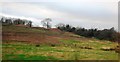
Field by Old Newton Road
Looking over the gate at the foot of the track shown in Image In the background is Zig Zag Quarry.
Image: © Derek Harper
Taken: 21 Jan 2013
0.05 miles
8
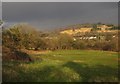
Meadow by Old Newton Road
Looking to the right from the gate seen in Image Across the field is the railway line (see also Image]); beyond is housing on the north end of Kingskerswell, with the Aller Brook running along this edge of the nearest houses. On the far hillside are Zig Zag quarry (left) and Harpins Brake (right).
Image: © Derek Harper
Taken: 21 Jan 2013
0.05 miles
9
Old Newton Road
The road north of Kingskerswell passes a track leading up the bank on the left.
Image: © Derek Harper
Taken: 21 Jan 2013
0.06 miles
10
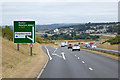
South Devon Highway bypassing Kingskerswell
The South Devon Highway (or Kingskerswell Bypass) connects Torbay and Newton Abbot, bypassing the A380 between Penn Inn, Newton Abbot and Kerswell Gardens in Torquay, which was one of the most choked up and heavily used roads in the South West, carrying more than 35,000 vehicles a day. Construction of the 3.4 mile (5.5km) dual carriageway began in 2012 and it was opened in 2015.
Image: © David Dixon
Taken: 23 Jul 2018
0.07 miles