IMAGES TAKEN NEAR TO
Brookedor Gardens, NEWTON ABBOT, TQ12 5JT
Introduction
This page details the photographs taken nearby to Brookedor Gardens, TQ12 5JT by members of the Geograph project.
The Geograph project started in 2005 with the aim of publishing, organising and preserving representative images for every square kilometre of Great Britain, Ireland and the Isle of Man.

There are currently over 7.5m images from over14,400 individuals and you can help contribute to the project by visiting https://www.geograph.org.uk
Image Map
Images are licensed for reuse under creativecommons.org/licenses/by-sa/2.0
Notes
- Clicking on the map will re-center to the selected point.
- The higher the marker number, the further away the image location is from the centre of the postcode.
Image Listing (169 Images Found)
Images are licensed for reuse under creativecommons.org/licenses/by-sa/2.0
Image
Details
Distance
1
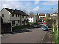
School Road, Kingskerswell
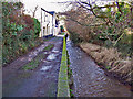
School Road drops down to cross the Aller Brook, past the modern Brookedor Gardens on the left (built on a former caravan site). The road continues as Coles Lane past the thatched cottage. Taken from close to Image
Image: © Derek Harper
Taken: 24 Feb 2007
0.01 miles
2
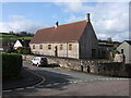
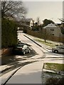
Kingskerswell Community Centre
This used to be the primary school, which is now housed in modern premises on the other side of the A380. The building, which dates from 1856, is on a road called Dobbin Arch, which crosses the railway line on one of two listed bridges in the village. In the foreground is School Road.
Image: © Derek Harper
Taken: 24 Feb 2007
0.02 miles
3
![Kingskerswell buildings [31]](https://s0.geograph.org.uk/geophotos/06/19/58/6195800_ef04452e_120x120.jpg)
Kingskerswell buildings [31]
The former school is now a community and leisure centre.
Image: © Michael Dibb
Taken: 27 May 2019
0.02 miles
4
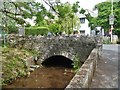
Over the brook
This small bridge carries School Road over Aller Brook.
Image: © Michael Dibb
Taken: 27 May 2019
0.02 miles
5
![Kingskerswell buildings [1]](https://s2.geograph.org.uk/geophotos/06/19/07/6190722_9589a13f_120x120.jpg)
Kingskerswell buildings [1]
Number 1 Coles Lane is late 17th century, altered in the 18th century and extended and modernised in the 20th century. Listed, grade II, with details at: https://historicengland.org.uk/listing/the-list/list-entry/1164911
Image: © Michael Dibb
Taken: 27 May 2019
0.03 miles
6
![Kingskerswell buildings [2]](https://s3.geograph.org.uk/geophotos/06/19/07/6190731_5533d48e_120x120.jpg)
Kingskerswell buildings [2]
This wooden building, on the unusually named road Dobbin Arch, is the headquarters of the local scout group.
Image: © Michael Dibb
Taken: 27 May 2019
0.03 miles
7
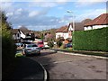
Brook Orchard, Kingskerswell
Another close built across the former caravan site at Brookeador, close to the Aller Brook (see Image).
Image: © Derek Harper
Taken: 24 Feb 2007
0.04 miles
8
Aller Brook
Here, the brook flows through a residential area of Kingskerswell on its way to join the River Teign at Newton Abbot.
Image: © Richard Dorrell
Taken: 19 Jan 2011
0.05 miles
9
Dobbin Arch
This snowy cul-de-sac in Kingskerswell is named after the nearby railway bridge.
Image: © Derek Harper
Taken: 17 Dec 2010
0.06 miles
10
![Kingskerswell buildings [29]](https://s0.geograph.org.uk/geophotos/06/19/57/6195796_daf78a47_120x120.jpg)
Kingskerswell buildings [29]
The hall in School Road. Facilities include a badminton court.
Image: © Michael Dibb
Taken: 27 May 2019
0.07 miles