IMAGES TAKEN NEAR TO
Valerie Rise, Torquay Road, NEWTON ABBOT, TQ12 5FT
Introduction
This page details the photographs taken nearby to Valerie Rise, Torquay Road, TQ12 5FT by members of the Geograph project.
The Geograph project started in 2005 with the aim of publishing, organising and preserving representative images for every square kilometre of Great Britain, Ireland and the Isle of Man.

There are currently over 7.5m images from over14,400 individuals and you can help contribute to the project by visiting https://www.geograph.org.uk
Image Map
Images are licensed for reuse under creativecommons.org/licenses/by-sa/2.0
Notes
- Clicking on the map will re-center to the selected point.
- The higher the marker number, the further away the image location is from the centre of the postcode.
Image Listing (64 Images Found)
Images are licensed for reuse under creativecommons.org/licenses/by-sa/2.0
Image
Details
Distance
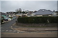
1
A380, Kingskerswell
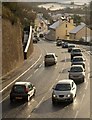
Taken about five minutes after Image, with snow only on roofs and fields. In the background, the Torquay road stretches away to the southern end of the village.
Image: © Derek Harper
Taken: 17 Dec 2010
0.03 miles
2
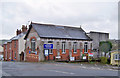
Kingskerswell Methodist Church
Located at the junction between Water Lane and Torquay Road.
Image: © Richard Dorrell
Taken: 26 Mar 2010
0.06 miles
3
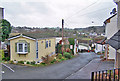
Waterdale Mobile Home Park
A small park of very permanent-looking mobile homes just off Water Lane, Kingskerswell.
Image: © Richard Dorrell
Taken: 26 Mar 2010
0.06 miles
7
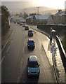
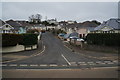
A380, Kingskerswell
Taken less than 40 seconds after Image, with the snow shower almost halted and the sun breaking through. The queue is typical; the traffic lights at Jury's Corner create tailbacks in each direction throughout the day.
Image: © Derek Harper
Taken: 17 Dec 2010
0.08 miles
8
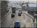
A380 in the snow
The Torquay Road seen through a snow shower from the bridge carrying Fore Street (shown in Image).
Image: © Derek Harper
Taken: 17 Dec 2010
0.08 miles
9
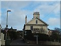
Fluder Hill
House at the junction of Fluder Hill and Southey Lane
Image: © David Smith
Taken: 25 Feb 2012
0.11 miles
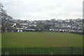
10
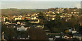
Kingskerswell
A view across the village from the car park at Kerswell Down Hill.
Image: © Derek Harper
Taken: 18 Nov 2020
0.11 miles