IMAGES TAKEN NEAR TO
Palm Rise, NEWTON ABBOT, TQ12 5FQ
Introduction
This page details the photographs taken nearby to Palm Rise, TQ12 5FQ by members of the Geograph project.
The Geograph project started in 2005 with the aim of publishing, organising and preserving representative images for every square kilometre of Great Britain, Ireland and the Isle of Man.

There are currently over 7.5m images from over14,400 individuals and you can help contribute to the project by visiting https://www.geograph.org.uk
Image Map
Images are licensed for reuse under creativecommons.org/licenses/by-sa/2.0
Notes
- Clicking on the map will re-center to the selected point.
- The higher the marker number, the further away the image location is from the centre of the postcode.
Image Listing (21 Images Found)
Images are licensed for reuse under creativecommons.org/licenses/by-sa/2.0
Image
Details
Distance
2
View of Wolborough Hill, Newton Abbot
Wolborough Hill spans SX8570 and SX8670. The view is from Fluder Hill near Kings Manor.
Image: © Robin Stott
Taken: 7 May 2012
0.05 miles
3
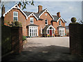
Kings Manor, Fluder Hill
So far I've been unable to find out anything about this handsome building. It is not the same as the Manor House in Kingskerswell, which is a ruin.
Image: © Robin Stott
Taken: 7 May 2012
0.06 miles
5
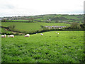
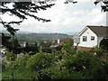
Fields southwest of Kingskerswell
The southern corner of Kingskerswell shows right of centre. On the left is Edginswell, now one of Torquay's outer suburbs.
Image: © Robin Stott
Taken: 7 May 2012
0.10 miles
6
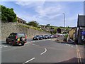
Kingskerswell
This is the main Exeter to Torquay road. Traffic flow gets pretty slow owing to the single lane road and a set of traffic lights. Saturdays in season is awful.
Image: © Richard Knights
Taken: 8 Jul 2005
0.10 miles
7
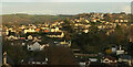
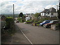
Kingskerswell
A view across the village from the car park at Kerswell Down Hill.
Image: © Derek Harper
Taken: 18 Nov 2020
0.12 miles
9
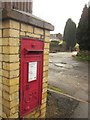
Postbox, Kingskerswell
This George V postbox, number TQ12 151, is in a brick pillar at the bottom of Southey Drive where it meets the main Torquay Road.
Image: © Derek Harper
Taken: 16 Dec 2012
0.15 miles
10
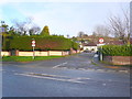
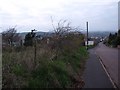
Fairfield Rd
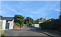
Fairfield Rd is a small residential road just off the A380 at the southern edge of Kingkerswell. It has a prohibition of motor vehicles (except for access) to prevent it being used as a rat-run cut through to Southey Lane.
Image: © Nigel Mykura
Taken: 27 Jan 2014
0.15 miles