IMAGES TAKEN NEAR TO
Fore Street, NEWTON ABBOT, TQ12 5FG
Introduction
This page details the photographs taken nearby to Fore Street, TQ12 5FG by members of the Geograph project.
The Geograph project started in 2005 with the aim of publishing, organising and preserving representative images for every square kilometre of Great Britain, Ireland and the Isle of Man.

There are currently over 7.5m images from over14,400 individuals and you can help contribute to the project by visiting https://www.geograph.org.uk
Image Map
Images are licensed for reuse under creativecommons.org/licenses/by-sa/2.0
Notes
- Clicking on the map will re-center to the selected point.
- The higher the marker number, the further away the image location is from the centre of the postcode.
Image Listing (112 Images Found)
Images are licensed for reuse under creativecommons.org/licenses/by-sa/2.0
Image
Details
Distance
1
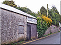
Former shoe repair shop
The sign says 'Shoe repair service', but it's been a while since any hob nails were hammered into boots in this shop at the top of Barnhill Road, Kingskerswell.
Image: © Richard Dorrell
Taken: 26 Mar 2010
0.02 miles
2
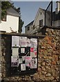
Noticeboard, Kingskerswell
I seem to recall Percy Young writing that he judged the character of unfamiliar settlements by the number of notices on the noticeboard. By that reckoning, Kingskerswell seems a vibrant place. This is at the junction of Barnhill Road and Fore Street.
Image: © Derek Harper
Taken: 5 Mar 2013
0.02 miles
3
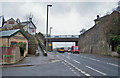
Torquay Road, Kingskerswell
Torquay Road is the ever-busy A380 connecting Torquay and Newton Abbot. It is not unusual for traffic to come to crawl, stop-start in both directions here during the summer months. This view is south towards Torquay from the junction with Embury Close. On the left is an Electricity building ( Image] ) and just beyond it a sloping footpath which connects to Fore Street, next to the Lord Nelson pub ( Image] ). The bridge carries Fore Street. Approximate retrospective view from the bridge - Image] .
Image: © Richard Dorrell
Taken: 26 Mar 2010
0.02 miles
4
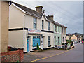
Catering and Family Butchers, Kingskerswell
Located in Fore Street. The shop premises would appear to occupy a former house.
Image: © Richard Dorrell
Taken: 26 Mar 2010
0.02 miles
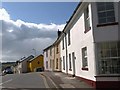
5
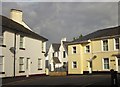
Houses in Kingskerswell
The top of Water Lane and its junction with Fore Street.
Image: © Derek Harper
Taken: 30 Oct 2013
0.02 miles
6
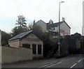
Former Torquay Electricity Undertaking sub-station
This sub-station was originally built to assist the supply of electricity from Newton Abbot power station to Torquay.
Image: © John C
Taken: 22 Apr 2018
0.03 miles
7
Terrace, Kingskerswell
A terrace on a snowy Fore Street, with the junction with Barnhill Road on the right.
Image: © Derek Harper
Taken: 17 Dec 2010
0.03 miles
8
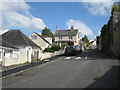
Top of Barnhill Road
Approaching its junction with Fore Street. Note the house of cream Kingsteignton brick, centre.
Image: © Robin Stott
Taken: 7 May 2012
0.03 miles
9
Water Lane, Kingskerswell
The terraces are on the west side of the short lane that connects Fore Street to the main Torquay Road as it emerges from beneath the bridge. There must have once been houses opposite until the construction of the modern road.
Image: © Derek Harper
Taken: 10 Apr 2008
0.03 miles
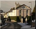
10
![Kingskerswell buildings [24]](https://s3.geograph.org.uk/geophotos/06/19/48/6194871_dff8e772_120x120.jpg)
Kingskerswell buildings [24]
This relatively unusual survival of an early 19th century shopfront in a fairly unaltered state is now sadly damaged and neglected. Listed, grade II, with details at: https://historicengland.org.uk/listing/the-list/list-entry/1097295
Image: © Michael Dibb
Taken: 27 May 2019
0.03 miles