IMAGES TAKEN NEAR TO
The Tors, NEWTON ABBOT, TQ12 5DR
Introduction
This page details the photographs taken nearby to The Tors, TQ12 5DR by members of the Geograph project.
The Geograph project started in 2005 with the aim of publishing, organising and preserving representative images for every square kilometre of Great Britain, Ireland and the Isle of Man.

There are currently over 7.5m images from over14,400 individuals and you can help contribute to the project by visiting https://www.geograph.org.uk
Image Map
Images are licensed for reuse under creativecommons.org/licenses/by-sa/2.0
Notes
- Clicking on the map will re-center to the selected point.
- The higher the marker number, the further away the image location is from the centre of the postcode.
Image Listing (288 Images Found)
Images are licensed for reuse under creativecommons.org/licenses/by-sa/2.0
Image
Details
Distance
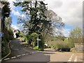
1
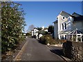
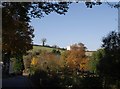
The Tors
Victorian villas on the crest of a hill overlooking Kingskerswell.
Image: © Derek Harper
Taken: 2 Nov 2007
0.02 miles
2
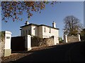
Villa on The Tors, Kingskerswell
Endean Priors dates from 1865 and is one of the rather good-looking Victorian villas on a hill overlooking Kingskerswell.
Image: © Derek Harper
Taken: 2 Nov 2007
0.03 miles
3
The Tors from Timber Terrace
Looking across Yon Street, with Victorian villas (The Tors) on the hill.
Image: © Derek Harper
Taken: 2 Nov 2007
0.03 miles
4
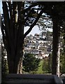
View from The Tors
It's the villas themselves that get the best views from The Tors, so the pedestrian has to make do with odd glimpses, such as this, showing part of Kingskerswell between two conifers.
Image: © Derek Harper
Taken: 2 Nov 2007
0.04 miles
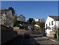
5
Junction, Kingskerswell
Another view of the crossroads shown in Image], with a view up The Tors on the left.
Image: © Derek Harper
Taken: 8 Apr 2014
0.05 miles
6
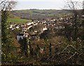
Kingskerswell from Kerswell Down
A detail of the scene in Image The clearance of trees on the hill at least means that new views of the village are obtained. Behind is the upper Aller Brook valley.
Image: © Derek Harper
Taken: 14 Feb 2013
0.05 miles
7
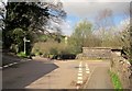
Junction, Kingskerswell
A crossroads (also shown in Image) with Rose Hill turning off right across the railway bridge shown in Image], and the Tors climbing to the left. Ahead is the tower of St Mary's Church - see http://www.geograph.org.uk/search.php?i=49066812 .
Image: © Derek Harper
Taken: 8 Apr 2014
0.06 miles
8
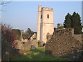
St Mary's Church, Kingskerswell
The church with its tapering tower is seen from neighbouring ruins connected to the nearby ruined manor house.
Image: © Derek Harper
Taken: 10 May 2006
0.06 miles
9
Church End Road, Kingskerswell
Looking down the shady road from near Rose Hill Bridge. The tower of Image peers above the trees, and a fragment of the churchyard can be seen to the left by the road junction.
Image: © Derek Harper
Taken: 2 Nov 2007
0.06 miles
10
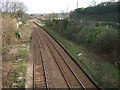
Site of Kingskerswell station
Looking south along the railway track from Image, showing the remaining evidence of the platforms. There seems to be a good deal of support for re-opening the station (closed in 1964), which should certainly reduce traffic on the road seen in Image
Image: © Derek Harper
Taken: 24 Feb 2007
0.06 miles