IMAGES TAKEN NEAR TO
Daccabridge Road, NEWTON ABBOT, TQ12 5DQ
Introduction
This page details the photographs taken nearby to Daccabridge Road, TQ12 5DQ by members of the Geograph project.
The Geograph project started in 2005 with the aim of publishing, organising and preserving representative images for every square kilometre of Great Britain, Ireland and the Isle of Man.

There are currently over 7.5m images from over14,400 individuals and you can help contribute to the project by visiting https://www.geograph.org.uk
Image Map
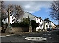
Images are licensed for reuse under creativecommons.org/licenses/by-sa/2.0
Notes
- Clicking on the map will re-center to the selected point.
- The higher the marker number, the further away the image location is from the centre of the postcode.
Image Listing (193 Images Found)
Images are licensed for reuse under creativecommons.org/licenses/by-sa/2.0
Image
Details
Distance
1
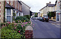
Fore Street, Kingskerswell
The heart of this large south Devon village with a pharmacy (which is no longer there) on the immediate right and the post office a little further along.
Image: © Stephen McKay
Taken: Unknown
0.03 miles
2
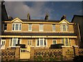
Houses on Fore Street, Kingskerswell
There's an element of railway architecture in the decoration of this trio of houses set back from Fore Street, where other buildings are more or less straight on to the pavement.
Image: © Derek Harper
Taken: 21 Jan 2013
0.04 miles
3
![Kingskerswell buildings [20]](https://s3.geograph.org.uk/geophotos/06/19/48/6194863_d141af7f_120x120.jpg)
Kingskerswell buildings [20]
This fine and imposing mid 19th century warehouse is sadly neglected with the floors and internal features having been removed. Listed, grade II, with details at: https://historicengland.org.uk/listing/the-list/list-entry/1164936 See also Image
Image: © Michael Dibb
Taken: 27 May 2019
0.04 miles
4
![Kingskerswell buildings [21]](https://s1.geograph.org.uk/geophotos/06/19/48/6194865_e4f5351f_120x120.jpg)
Kingskerswell buildings [21]
This fine and imposing mid 19th century warehouse is sadly neglected with the floors and internal features having been removed. Listed, grade II, with details at: https://historicengland.org.uk/listing/the-list/list-entry/1164936 See also Image
Image: © Michael Dibb
Taken: 27 May 2019
0.04 miles
5
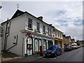
Kingskerswell Post Office
kkpo, as it is known, is one of a line of shops along the north side of Fore Street.
Image: © Derek Harper
Taken: 14 Jul 2009
0.04 miles
6
Buildings on Fore Street, Kingskerswell
At the entrance to Rose Hill Close (left) and including, three doors along, kkpo Image
Image: © Derek Harper
Taken: 16 Feb 2015
0.04 miles
7
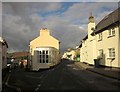
Kingskerswell: War Memorial and Fore Street
Looking along the main village shopping street from the junction with Rose Hill and Halls Lane, with the war memorial set in a small embayment beside the mini-roundabout.
Image: © Derek Harper
Taken: 24 Feb 2007
0.05 miles
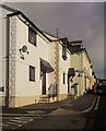
8
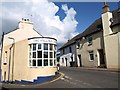
Junction, Kingskerswell
Another view of Image in the angle of Daccabridge Road and Fore Street. Both streets immediately cross into Image
Image: © Derek Harper
Taken: 30 Oct 2013
0.06 miles
9
Hairdressers, Kingskerswell
The Village Salon occupies a strange little building in the angle between Daccabridge Road (left) and Fore Street. This is right at the western edge of the square; the white cottage on Fore Street is across in Image
Image: © Derek Harper
Taken: 10 Apr 2008
0.06 miles
10
![Kingskerswell buildings [23]](https://s0.geograph.org.uk/geophotos/06/19/48/6194868_07e7b1b3_120x120.jpg)
Kingskerswell buildings [23]
Forge Cottage is probably early 18th century and is listed, grade II, with details at: https://historicengland.org.uk/listing/the-list/list-entry/1097262
Image: © Michael Dibb
Taken: 27 May 2019
0.06 miles