IMAGES TAKEN NEAR TO
Exeter Road, NEWTON ABBOT, TQ12 3NS
Introduction
This page details the photographs taken nearby to Exeter Road, TQ12 3NS by members of the Geograph project.
The Geograph project started in 2005 with the aim of publishing, organising and preserving representative images for every square kilometre of Great Britain, Ireland and the Isle of Man.

There are currently over 7.5m images from over14,400 individuals and you can help contribute to the project by visiting https://www.geograph.org.uk
Image Map
Images are licensed for reuse under creativecommons.org/licenses/by-sa/2.0
Notes
- Clicking on the map will re-center to the selected point.
- The higher the marker number, the further away the image location is from the centre of the postcode.
Image Listing (54 Images Found)
Images are licensed for reuse under creativecommons.org/licenses/by-sa/2.0
Image
Details
Distance
1
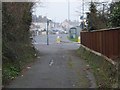
Public footpath in Sandygate
This road has been closed to through traffic, and is a well-used footpath from Sandygate to Higher Sandygate.
Image: © David Smith
Taken: 13 Mar 2012
0.01 miles
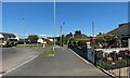
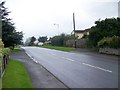
2
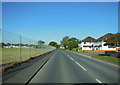
Exeter Road, Kingsteignton
Looking towards its junction with Strap Lane.
Image: © Robin Stott
Taken: 5 Jan 2010
0.02 miles
3
Five Lanes, Kingsteignton
The near turn to the right is Lindridge Lane leading eventually up to Little Haldon; the further turn is Exeter Road B3195, seen also in the foreground. To the right is Strap Lane and, in shadow beyond the island, a closed road, possibly an even earlier Exeter Road through Sandygate. The white houses were built in the 1980s or 1990s though the house on the left edge of the photo may date from before World War II.
Image: © Robin Stott
Taken: 26 Apr 2022
0.03 miles
4
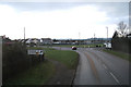
Junction of Exeter Road and Lindridge Lane, Kingsteignton
Exeter Road leads to and from the A380. Lindridge Lane, near right, runs northeast becoming Hestow Road climbing to the Little Haldon villages. Some maps call this spot Five Lanes but the other three are out of shot. Big wagons, like that on the left, are a common sight in the area. Until 1950, say, this was the northern extent of the village: the bungalows and garden walls, right, could well be from the 1930s. The K6 phone box is a garden ornament.
Image: © Robin Stott
Taken: 26 Apr 2022
0.04 miles
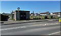
5
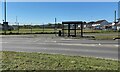
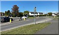
Bus stop, Exeter Road, Kingsteignton
Stagecoach service 2, Newton Abbot-Exeter, makes a long detour round Kingsteignton's innumerable housing estates. There may be other local services. This stop is just south of the Five Lanes roundabout. Strap Lane, right, heads for the western side of the village, Sandygate and perhaps Chudleigh.
Image: © Robin Stott
Taken: 26 Apr 2022
0.04 miles
6
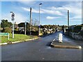
Kingsteignton : Lindridge Lane
From the roundabout looking along Lindridge Lane.
Image: © Lewis Clarke
Taken: 28 Nov 2022
0.05 miles
7
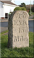
Old Milestone by the B3195, Exeter Road, Kingsteignton Parish
Carved stone post by the B3195 (was A380), in parish of KINGSTEIGNTON (TEIGNBRIDGE District), Exeter Road, 60m South of Ten Tors Inn, at entrance to Sandygate Mill Road, on grass verge in front of house, on West side of road. Newton faces (new), erected by the Totnes and Bridgetown-Pomeroy turnpike trust in the 19th century.
Inscription reads:-
: To / Exon / 13 / Miles : : To / Totnes / 11 / Miles :
Grade II listed.
List Entry Number: 1317450 https://historicengland.org.uk/listing/the-list/list-entry/1317450
Milestone Society National ID: DV_EXTN13.
Image: © Alan Rosevear
Taken: 21 Feb 2008
0.05 miles
8
Gas installation, footpath and Five Lanes Playing Field, Kingsteignton
The gas thing is by Wales & West Utilities. The footpath leads to Meadowcroft Drive and Sandygate.
Image: © Robin Stott
Taken: 26 Apr 2022
0.05 miles
9
Street scene, Sandygate
Exeter Road.
Image: © Maigheach-gheal
Taken: 18 Aug 2008
0.06 miles