IMAGES TAKEN NEAR TO
Coronation Road, NEWTON ABBOT, TQ12 3LJ
Introduction
This page details the photographs taken nearby to Coronation Road, TQ12 3LJ by members of the Geograph project.
The Geograph project started in 2005 with the aim of publishing, organising and preserving representative images for every square kilometre of Great Britain, Ireland and the Isle of Man.

There are currently over 7.5m images from over14,400 individuals and you can help contribute to the project by visiting https://www.geograph.org.uk
Image Map
Images are licensed for reuse under creativecommons.org/licenses/by-sa/2.0
Notes
- Clicking on the map will re-center to the selected point.
- The higher the marker number, the further away the image location is from the centre of the postcode.
Image Listing (57 Images Found)
Images are licensed for reuse under creativecommons.org/licenses/by-sa/2.0
Image
Details
Distance
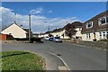
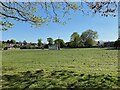
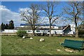
3
Clifford Park, Kingsteignton
This open space would have been provided as an amenity for the nearby council housing estate. It has traditional play equipment as well as more recent introductions – fitness equipment. There is a skate park, a multi-use games area (MUGA) and bags of room for informal activities.
Image: © Robin Stott
Taken: 25 Apr 2022
0.05 miles
4
Clifford Park, Kingsteignton, in spring
Image: © Robin Stott
Taken: 25 Apr 2022
0.06 miles
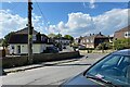
5
Rear of the Royal British Legion clubhouse, Ley Lane, Kingsteignton
The view is from Clifford Park.
Image: © Robin Stott
Taken: 25 Apr 2022
0.08 miles
6
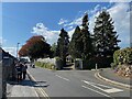
Corner of Ley Lane and Football Lane, Kingsteignton
The chalet-style house among the conifers is called Blossomdays.
Image: © Robin Stott
Taken: 25 Apr 2022
0.10 miles
7
Higher Mills in the course of refurbishment, Crossley Moor Road, Kingsteignton
Higher Mills is a listed building: https://historicengland.org.uk/listing/the-list/list-entry/1334256?section=official-list-entry Two young men who were working in the house told me that the building had been a corn mill, later a butcher's shop. There was a natural spring underneath the building (which I don't believe, because the mill was powered by a leat). There had been a fire and it was being refurbished. They added with some pride "It's all new now."
Image: © Robin Stott
Taken: 25 Apr 2022
0.12 miles
8
North on Crossley Moor Road towards Higher Mills, Kingsteignton
Higher Mills is a listed building https://historicengland.org.uk/listing/the-list/list-entry/1334256?section=official-list-entry . From Historic England maps, the leat (flowing towards the camera and sometimes referred to as Fairwater) appears to be the diverting of a brook that rises from a spring at Rydon to the north.
Image: © Robin Stott
Taken: 25 Apr 2022
0.12 miles
9
A glimpse of Higher Mills during refurbishment, Crossley Moor Road, Kingsteignton
Higher Mills is a listed building: https://historicengland.org.uk/listing/the-list/list-entry/1334256?section=official-list-entry Two young men who were working in the house told me that the building had been a corn mill, later a butcher's shop. There was a natural spring underneath the building (hard to believe because the mill was powered by a leat). There had been a fire and it was being refurbished. They added with some pride "It's all new now."
Image: © Robin Stott
Taken: 25 Apr 2022
0.12 miles
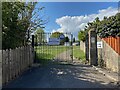
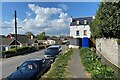
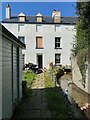
10
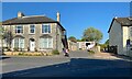
Rear accesses, Gestridge Road, Kingsteignton
The house on the left is better seen in Image
Image: © Robin Stott
Taken: 26 Apr 2022
0.12 miles