IMAGES TAKEN NEAR TO
Ley Lane, NEWTON ABBOT, TQ12 3JE
Introduction
This page details the photographs taken nearby to Ley Lane, TQ12 3JE by members of the Geograph project.
The Geograph project started in 2005 with the aim of publishing, organising and preserving representative images for every square kilometre of Great Britain, Ireland and the Isle of Man.

There are currently over 7.5m images from over14,400 individuals and you can help contribute to the project by visiting https://www.geograph.org.uk
Image Map
Images are licensed for reuse under creativecommons.org/licenses/by-sa/2.0
Notes
- Clicking on the map will re-center to the selected point.
- The higher the marker number, the further away the image location is from the centre of the postcode.
Image Listing (40 Images Found)
Images are licensed for reuse under creativecommons.org/licenses/by-sa/2.0
Image
Details
Distance
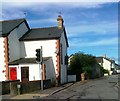
1
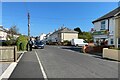
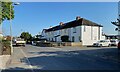
Corner of Ley Lane west and Robers Road, Kingsteignton
The street has the feel of a former council housing estate, with corner shop.
Image: © Robin Stott
Taken: 25 Apr 2022
0.02 miles
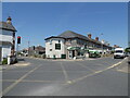
2
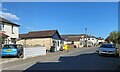
Two takeaways, Ley Lane west, Kingsteignton
Built of the characteristic cream brick of the area.
Image: © Robin Stott
Taken: 25 Apr 2022
0.06 miles
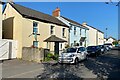
3
Houses of cream brick, Chudleigh Road, Kingsteignton
The cream bricks were made locally from local clay.
Image: © Robin Stott
Taken: 26 Apr 2022
0.09 miles
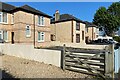
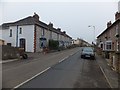
4
Older houses, north side of Chudleigh Road, Kingsteignton
Their date is not known but the location away from the village centre fits the impression of Kingsteignton's piecemeal expansion in the twentieth century.
Image: © Robin Stott
Taken: 26 Apr 2022
0.09 miles
7
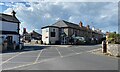
Junction of Ley Lane and Exeter Road, Kingsteignton
Exeter Road is the B3195. GM (stands for Green Machine) is a BMX bike store on the corner.
Image: © Robin Stott
Taken: 25 Apr 2022
0.10 miles
9
Terrace of five houses, Chudleigh Road, Kingsteignton
The terrace does look like former local authority housing. Comparison of gappy small-scale maps suggests that it was built in the 1950s. The furthest house, with the white gable end, may be part of the group, making it a terrace of six. The nearest house stands at the corner of Greenbank Avenue, which the same maps indicate was built before 1946.
Image: © Robin Stott
Taken: 26 Apr 2022
0.10 miles
10
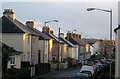
Houses on Exeter Road, Kingsteignton
It was the sun on the chimneys that caught my attention. Hidden, to all intents and purposes, between the first and second pair of semis on the left is a former gospel hall, converted to a house in about 2005. This road was, until the construction of Besigheim Way in the mid-1970s, the main road between Exeter and Newton Abbot.
Image: © Derek Harper
Taken: 13 Feb 2014
0.10 miles