IMAGES TAKEN NEAR TO
Clifford Street, NEWTON ABBOT, TQ12 3HD
Introduction
This page details the photographs taken nearby to Clifford Street, TQ12 3HD by members of the Geograph project.
The Geograph project started in 2005 with the aim of publishing, organising and preserving representative images for every square kilometre of Great Britain, Ireland and the Isle of Man.

There are currently over 7.5m images from over14,400 individuals and you can help contribute to the project by visiting https://www.geograph.org.uk
Image Map
Images are licensed for reuse under creativecommons.org/licenses/by-sa/2.0
Notes
- Clicking on the map will re-center to the selected point.
- The higher the marker number, the further away the image location is from the centre of the postcode.
Image Listing (94 Images Found)
Images are licensed for reuse under creativecommons.org/licenses/by-sa/2.0
Image
Details
Distance
1
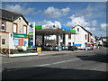
Harvest petrol filling station, Oakford Cross
It seems to be associated with the Londis shop, left.
Image: © Robin Stott
Taken: 8 May 2012
0.05 miles
2
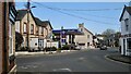
Junction of Broadway Road and Oakford B3195, Kingsteignton
Just round the corner from Office Supplies, right, is one of the accesses to the open space Oakford Lawn:
Image: © Robin Stott
Taken: 25 Apr 2022
0.06 miles
3
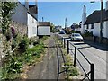
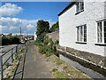
South on Crossley Moor Road and west aspect of Brookside
The side extension over the Mill Leat, referred to in Image, is seen here from the north. Brookside is a listed building https://historicengland.org.uk/listing/the-list/list-entry/1334277?section=official-list-entry . From Historic England maps, the leat (sometimes called Fairwater) appears to be the diverting of a brook that rises from a spring at Rydon to the north.
Image: © Robin Stott
Taken: 25 Apr 2022
0.06 miles
4
Private bridge across Mill Leat, Crossley Moor Road, Kingsteignton
The view is south. From Historic England maps, the leat appears to be the diverting of a brook that rises from a spring at Rydon to the north. It ducks under Fore Street, ahead, to rejoin its parent watercourse before flowing to the Teign. It adds a timeless element to the street. The sound of the water is a refreshing change from traffic noise.
Image: © Robin Stott
Taken: 25 Apr 2022
0.06 miles
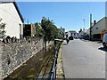
5
North on Crossley Moor Road by Mill Leat, Kingsteignton
From Historic England maps, the leat (flowing towards the camera and sometimes referred to as Fairwater) appears to be the diverting of a brook that rises from a spring at Rydon to the north. There is a property up the road labelled Higher Mills, a listed building.
Image: © Robin Stott
Taken: 25 Apr 2022
0.06 miles
6

Houses at Oakford Cross
Much of Kingsteignton is built of brick, and the paler brick dressings are particularly characteristic. Close by are extensive clay pits.
On the left is Broadway Road; on the right, on the right Gestridge Road, the B3195 (and formerly the main road from Newton Abbot to Exeter).
Image: © Derek Harper
Taken: 16 Oct 2008
0.07 miles
7
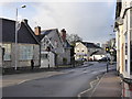
Fore Street, Kingsteignton
There is a school on the left.
Image: © Chris Allen
Taken: 23 Dec 2015
0.07 miles
8
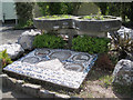
Millennium mosaic and planters, Kingsteignton
The legend on the mosaic is "Kingsteignton Second Millennium". The small plaques on the planters appear to commemorate former members of the parish council, including a Councillor John Close.
Image: © Robin Stott
Taken: 8 May 2012
0.07 miles
9
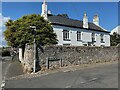
Brookside, 1 Golvers Hill Road, Kingsteignton
Historic England says "probably 18th- or early 19th century". The brook referred to in the name is actually a mill leat. It is channelled along Crossley Moor Road (left) towards (south) and beneath the camera. The listed building description points out an extension over the leat at the west (near) end of the building https://historicengland.org.uk/listing/the-list/list-entry/1334277?section=official-list-entry The list entry refers once to Glovers Hill Road: possibly a typo for 'Golvers' but persuasive and convincing nevertheless.
Image: © Robin Stott
Taken: 25 Apr 2022
0.07 miles
10

Kingsteignton Youth Centre, Broadway Road
It may be Youth Club. Cannot find any information. The plaque below the canopy reads: This stone was laid by Teresa Thomas on behalf of Reg Thomas "our top man" July [?] 2004.
Image: © Robin Stott
Taken: 8 May 2012
0.07 miles