IMAGES TAKEN NEAR TO
Wolverton Drive, NEWTON ABBOT, TQ12 3EY
Introduction
This page details the photographs taken nearby to Wolverton Drive, TQ12 3EY by members of the Geograph project.
The Geograph project started in 2005 with the aim of publishing, organising and preserving representative images for every square kilometre of Great Britain, Ireland and the Isle of Man.

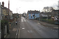
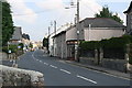
There are currently over 7.5m images from over14,400 individuals and you can help contribute to the project by visiting https://www.geograph.org.uk
Image Map
Images are licensed for reuse under creativecommons.org/licenses/by-sa/2.0
Notes
- Clicking on the map will re-center to the selected point.
- The higher the marker number, the further away the image location is from the centre of the postcode.
Image Listing (80 Images Found)
Images are licensed for reuse under creativecommons.org/licenses/by-sa/2.0
Image
Details
Distance
1
Bus stop, Gestridge Road, Kingsteignton
At its junction with Whiteway Road, right. The name recalls one of the clay companies that quarried in the Bovey Basin to the northwest.
Image: © Robin Stott
Taken: 5 Jan 2010
0.05 miles
2
Broadway Road approaches the village centre, Kingsteignton
A sign alerts people to traffic calming ahead.
Image: © Robin Stott
Taken: 25 Apr 2022
0.07 miles
3
Traffic calming, Broadway Road, Kingsteignton
Much needed on this road of constant traffic, some of it rather fast.
Image: © Robin Stott
Taken: 25 Apr 2022
0.07 miles
4
Kingsteignton Health Centre and bus stop, Gestridge Road, Kingsteignton
At the corner of Whiteway Road. Whiteway – didn't that use to be a popular brand of cider? The view is from a No 2 bus en route to Newton Abbot.
Image: © Robin Stott
Taken: 16 May 2018
0.08 miles
5
Gestridge Road Kingsteignton
A typical 'mixed bag' of housing types on this street which is one of the main thoroughfares in Kingsteignton.
Image: © Tony Atkin
Taken: 18 Sep 2008
0.08 miles
6
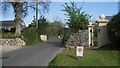
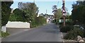
Gate pillars and a narrowing of Broadway Road, Kingsteignton
Older properties with mature hedges and hedgebanks fronting the road are a sign of Kingsteignton's early expansion. It's a busy road; one can sense drivers' frustration at its pinchpoints.
Image: © Robin Stott
Taken: 25 Apr 2022
0.08 miles
7
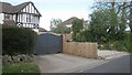
Boundaries, Broadway Road, Kingsteignton
Image: © Robin Stott
Taken: 25 Apr 2022
0.09 miles
8
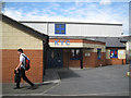
Kingsteignton Youth Centre, Broadway Road
It may be Youth Club. Cannot find any information. The plaque below the canopy reads: This stone was laid by Teresa Thomas on behalf of Reg Thomas "our top man" July [?] 2004.
Image: © Robin Stott
Taken: 8 May 2012
0.10 miles
9
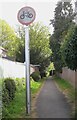
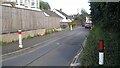
No cycling off Broadway Road, Kingsteignton
Image: © Robin Stott
Taken: 25 Apr 2022
0.10 miles
10
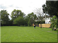
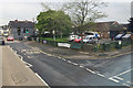
Northwest corner of Oakford Lawn
Oakford Lawn is a quiet, spacious public park tucked away behind Broadway Road, which serves the properties on the right. The rear of the Oakford House property is out of shot, right.
Image: © Robin Stott
Taken: 8 May 2012
0.10 miles