IMAGES TAKEN NEAR TO
Orchard Gardens, NEWTON ABBOT, TQ12 3AP
Introduction
This page details the photographs taken nearby to Orchard Gardens, TQ12 3AP by members of the Geograph project.
The Geograph project started in 2005 with the aim of publishing, organising and preserving representative images for every square kilometre of Great Britain, Ireland and the Isle of Man.

There are currently over 7.5m images from over14,400 individuals and you can help contribute to the project by visiting https://www.geograph.org.uk
Image Map
Images are licensed for reuse under creativecommons.org/licenses/by-sa/2.0
Notes
- Clicking on the map will re-center to the selected point.
- The higher the marker number, the further away the image location is from the centre of the postcode.
Image Listing (91 Images Found)
Images are licensed for reuse under creativecommons.org/licenses/by-sa/2.0
Image
Details
Distance
1

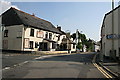
Fore Street, Kingsteignton
A pleasing group of vernacular buildings in old Kingsteignton. The building on the right is the former school house; the extended school is out of sight behind it.
Image: © Robin Stott
Taken: 8 May 2012
0.04 miles
2
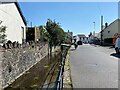
Private bridge across Mill Leat, Crossley Moor Road, Kingsteignton
The view is south. From Historic England maps, the leat appears to be the diverting of a brook that rises from a spring at Rydon to the north. It ducks under Fore Street, ahead, to rejoin its parent watercourse before flowing to the Teign. It adds a timeless element to the street. The sound of the water is a refreshing change from traffic noise.
Image: © Robin Stott
Taken: 25 Apr 2022
0.04 miles
3
Fore Street, Kingsteignton
There is a school on the left.
Image: © Chris Allen
Taken: 23 Dec 2015
0.04 miles
4
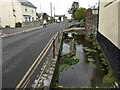
Stream beside Bell Inn, alongside Crossley Moor Road, Kingsteignton
Image: © David Gearing
Taken: 23 Feb 2012
0.04 miles
5
Harvest petrol filling station, Oakford Cross
It seems to be associated with the Londis shop, left.
Image: © Robin Stott
Taken: 8 May 2012
0.05 miles
6
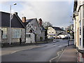
Fore Street Kingsteignton
The Bell Inn is the most prominent building here on the corner of Fore Street and Crossley Moor Road.
Image: © Tony Atkin
Taken: 18 Sep 2008
0.05 miles
7
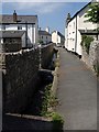
Fairwater Leat on Berry Lane, Kingsteignton
A view of Image at the northern end of the walled path that connects the church to Fore Street. The leat was probably cut in the late 13th or early 14th century.
Image: © Derek Harper
Taken: 23 Jun 2009
0.05 miles
8

Bell Inn, Kingsteignton
The pub is at the corner of Fore Street (ahead) and Crossley Moor Road. Its trade is "wet led" http://www.daltonsbusiness.com/UImages/BusinessDocuments/4704D1.pdf - which means a gastro-pub it isn't.
Image: © Derek Harper
Taken: 23 Jun 2009
0.05 miles
9
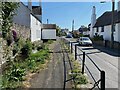
South on Crossley Moor Road and west aspect of Brookside
The side extension over the Mill Leat, referred to in Image, is seen here from the north. Brookside is a listed building https://historicengland.org.uk/listing/the-list/list-entry/1334277?section=official-list-entry . From Historic England maps, the leat (sometimes called Fairwater) appears to be the diverting of a brook that rises from a spring at Rydon to the north.
Image: © Robin Stott
Taken: 25 Apr 2022
0.06 miles
10
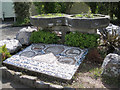
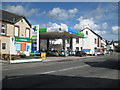
Millennium mosaic and planters, Kingsteignton
The legend on the mosaic is "Kingsteignton Second Millennium". The small plaques on the planters appear to commemorate former members of the parish council, including a Councillor John Close.
Image: © Robin Stott
Taken: 8 May 2012
0.06 miles