IMAGES TAKEN NEAR TO
Newton Road, NEWTON ABBOT, TQ12 3AJ
Introduction
This page details the photographs taken nearby to Newton Road, TQ12 3AJ by members of the Geograph project.
The Geograph project started in 2005 with the aim of publishing, organising and preserving representative images for every square kilometre of Great Britain, Ireland and the Isle of Man.

There are currently over 7.5m images from over14,400 individuals and you can help contribute to the project by visiting https://www.geograph.org.uk
Image Map
Images are licensed for reuse under creativecommons.org/licenses/by-sa/2.0
Notes
- Clicking on the map will re-center to the selected point.
- The higher the marker number, the further away the image location is from the centre of the postcode.
Image Listing (95 Images Found)
Images are licensed for reuse under creativecommons.org/licenses/by-sa/2.0
Image
Details
Distance
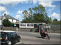
2
Newton Road, Kingsteignton, near the junction with Fore Street
Image: © David Gearing
Taken: 23 Feb 2012
0.01 miles
3
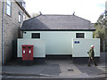
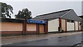
Public conveniences, Newton Road
In tasteful eau-de-nil. Postbox number TQ12 249.
Image: © Robin Stott
Taken: 8 May 2012
0.01 miles
4
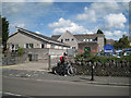
Access to primary school car park and a substation
Looking across Newton Road. The extension to the school is on the left.
Image: © Robin Stott
Taken: 8 May 2012
0.02 miles
5
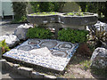
Millennium mosaic and planters, Kingsteignton
The legend on the mosaic is "Kingsteignton Second Millennium". The small plaques on the planters appear to commemorate former members of the parish council, including a Councillor John Close.
Image: © Robin Stott
Taken: 8 May 2012
0.02 miles
6
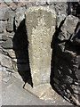
Old Milestone by the B3195, Newton Road, Kingsteignton
Carved stone post by the B3195, in parish of KINGSTEIGNTON (TEIGNBRIDGE District), Newton Road, 30m South of King's Arms roundabout, cemented onto wall on pavement above water leat, on East side of road. Erected by the Newton Bushell turnpike trust in the 18th century.
Inscription reads:-
: 1 / MILE TO / NEWTON / 14 / MILES TO / EXETER : : 14 / MILES TO / EXETER / 1 / MILE TO / NEWTON :
Grade II Listed. List Entry Number: 1165502
https://historicengland.org.uk/listing/the-list/list-entry/1165502
Milestone Society National ID: DV_EXTN14
Image: © T Jenkinson
Taken: 13 Aug 2010
0.02 miles
7
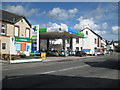
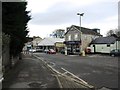
Harvest petrol filling station, Oakford Cross
It seems to be associated with the Londis shop, left.
Image: © Robin Stott
Taken: 8 May 2012
0.04 miles
8
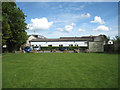
Northeast corner of Oakford Lawn and car park
The car park and the park are reached by an obscure entry off Oakford Cross. The long hut is the HQ of KOAPA – Kingsteignton Old Age Pensioners' Association.
Image: © Robin Stott
Taken: 8 May 2012
0.04 miles
9
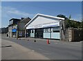
Closed open showroom, Kingsteignton
A gloomy scene on a very gloomy wet day on Newton Road, Kingsteignton. "Open to the public", it claims, but it clearly isn't. I'm afraid I can't even recollect what was on show. The range of buildings is marked as "works" on the map.
Image: © Derek Harper
Taken: 4 Oct 2008
0.04 miles
10
Kingsteignton Library, Newton Road
Old maps show two adjoining houses on this site. Seen from entrance to the Lidl store car park.
Image: © Robin Stott
Taken: 8 May 2012
0.04 miles