IMAGES TAKEN NEAR TO
Rundle Road, NEWTON ABBOT, TQ12 2PY
Introduction
This page details the photographs taken nearby to Rundle Road, TQ12 2PY by members of the Geograph project.
The Geograph project started in 2005 with the aim of publishing, organising and preserving representative images for every square kilometre of Great Britain, Ireland and the Isle of Man.

There are currently over 7.5m images from over14,400 individuals and you can help contribute to the project by visiting https://www.geograph.org.uk
Image Map
Images are licensed for reuse under creativecommons.org/licenses/by-sa/2.0
Notes
- Clicking on the map will re-center to the selected point.
- The higher the marker number, the further away the image location is from the centre of the postcode.
Image Listing (145 Images Found)
Images are licensed for reuse under creativecommons.org/licenses/by-sa/2.0
Image
Details
Distance
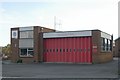
1
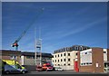
Newton Abbot fire station
Also shown in Image Here also are the drill tower, and dwelling on Harlington Court in the rear - the flats are "The Mill". The crane is at the new South Devon University Technical College building rising on Kingsteignton Road, on the site of Blacklers garage.
Image: © Derek Harper
Taken: 5 Jun 2015
0.05 miles
2
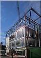
South Devon University Technical College
A new £10m building rises on the former site of Blacklers, the Renault dealership premises on Kingsteignton Road. "Designed by architects Stride Treglown, will house up to 600 students following specialist education in engineering and science" http://www.southdevonutc.org/location/ .
Image: © Derek Harper
Taken: 5 Jun 2015
0.06 miles
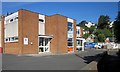
3
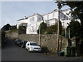
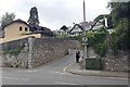
Seymour Road, Knowles Hill, Newton Abbot
Image: © Roger Cornfoot
Taken: 20 Nov 2008
0.06 miles
4
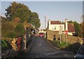
Rundle Road, Newton Abbot
All three roads are parts of Rundle Road. A little way down to the right is a T junction with Kingsteignton Road.
Image: © Derek Harper
Taken: 20 Nov 2013
0.07 miles
5
Rundle Road, off Kingsteignton Road, Newton Abbot
Houses climb the western slopes of Knowles Hill. The tall conifer, left, and the evergreen oaks, upper right, hark back to the nineteenth-century development of villas on the town's hills. The pale grey Devonian limestone has been used for walls.
Image: © Robin Stott
Taken: 23 Jul 2019
0.07 miles
6
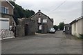
Cut-off length of Jetty Marsh Road, Newton Abbot
In the late 19th century Jetty Marsh Lane led from the town to Jetty Marsh Quay. By 1936 it had become Jetty Marsh Road. Around 1990 Jetty Marsh Road was widened and a roundabout built at the junction with Kingsteignton Road and Newton Road. This short stretch was bypassed. The stone building houses a home removals and storage company: Armstrong's. The building on the right is part of the premises of F Christophers and Son, independent funeral directors. This immediate area is shown on several old maps as King's Mews.
Image: © Robin Stott
Taken: 23 Jul 2019
0.07 miles
7
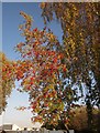
Rowan berries, Newton Abbot
A mountain ash in fruit on Kingsteignton Road, the B1935. In the background is a community centre used by local organisations.
Image: © Derek Harper
Taken: 20 Nov 2013
0.08 miles
8
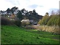
Knowles Hill from Templer Way
Nineteenth century villas on Knowles Hill look down on the reed-fringed Stover canal in the Jetty Marsh area. The Newton Road bridge crosses the canal. Those who could afford to built their houses on hills so as to be as far as possible from watercourses, which were often polluted with sewage and animal wastes. Regency, Victorian and Edwardian villas on hills are a feature of nearby Torquay and Teignmouth.
Image modified - lightest areas lightened.
Image: © Robin Stott
Taken: 12 Nov 2008
0.08 miles
9
Newton Abbot fire station
Newton Abbot fire station, Kingsteignton Road, Newton Abbot, Devon.
Image: © Kevin Hale
Taken: 8 Oct 2006
0.09 miles
10
Newton Abbot fire station
There is overlap with Image], which looks to the left. Behind to the right are houses on Knowles Hill.
Image: © Derek Harper
Taken: 5 Jun 2015
0.09 miles