IMAGES TAKEN NEAR TO
Knowles Hill Road, NEWTON ABBOT, TQ12 2PL
Introduction
This page details the photographs taken nearby to Knowles Hill Road, TQ12 2PL by members of the Geograph project.
The Geograph project started in 2005 with the aim of publishing, organising and preserving representative images for every square kilometre of Great Britain, Ireland and the Isle of Man.

There are currently over 7.5m images from over14,400 individuals and you can help contribute to the project by visiting https://www.geograph.org.uk
Image Map
Images are licensed for reuse under creativecommons.org/licenses/by-sa/2.0
Notes
- Clicking on the map will re-center to the selected point.
- The higher the marker number, the further away the image location is from the centre of the postcode.
Image Listing (193 Images Found)
Images are licensed for reuse under creativecommons.org/licenses/by-sa/2.0
Image
Details
Distance
1
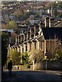
Knowles Hill Road, Newton Abbot
Looking down Knowles Hill Road with the junction with Bury Road on the right. Only the first house or two of the terrace is in square; the remainder are in Image
Image: © Derek Harper
Taken: 8 Apr 2009
0.04 miles
2
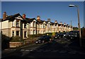
Garston Avenue, Newton Abbot
A road of terraced houses on Knowles Hill, seen from Bury Road.
Image: © Derek Harper
Taken: 8 Apr 2009
0.05 miles
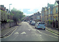
3
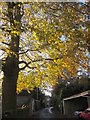
Rundle Road, Newton Abbot
The narrow road runs beneath an autumnal tree towards the junction with Knowles Hill Road.
Image: © Derek Harper
Taken: 20 Nov 2013
0.05 miles
4
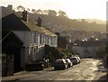
Bury Road, Newton Abbot
A terrace of four houses, oppoite the junction with Garston Avenue, and seen from the junction with Knowles Hill Road.
Image: © Derek Harper
Taken: 20 Nov 2013
0.07 miles
5
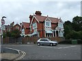
House in Abbotsbury Road, Newton Abbot
At the junction with the B3195
Image: © David Smith
Taken: 16 Sep 2010
0.09 miles
6
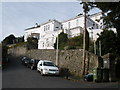
Seymour Road, Knowles Hill, Newton Abbot
Image: © Roger Cornfoot
Taken: 20 Nov 2008
0.09 miles
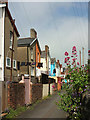
8
Rundle Road, Newton Abbot
All three roads are parts of Rundle Road. A little way down to the right is a T junction with Kingsteignton Road.
Image: © Derek Harper
Taken: 20 Nov 2013
0.11 miles
9
Knowles Hill from Templer Way
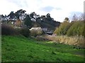
Nineteenth century villas on Knowles Hill look down on the reed-fringed Stover canal in the Jetty Marsh area. The Newton Road bridge crosses the canal. Those who could afford to built their houses on hills so as to be as far as possible from watercourses, which were often polluted with sewage and animal wastes. Regency, Victorian and Edwardian villas on hills are a feature of nearby Torquay and Teignmouth.
Image modified - lightest areas lightened.
Image: © Robin Stott
Taken: 12 Nov 2008
0.11 miles
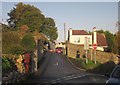
10
Back alley, Newton Abbot
Between Halcyon Road and Fisher Road, and seen from Newton Abbot footpath 49.
Image: © Derek Harper
Taken: 20 May 2018
0.12 miles