IMAGES TAKEN NEAR TO
Thurlestone Road, NEWTON ABBOT, TQ12 2NJ
Introduction
This page details the photographs taken nearby to Thurlestone Road, TQ12 2NJ by members of the Geograph project.
The Geograph project started in 2005 with the aim of publishing, organising and preserving representative images for every square kilometre of Great Britain, Ireland and the Isle of Man.

There are currently over 7.5m images from over14,400 individuals and you can help contribute to the project by visiting https://www.geograph.org.uk
Image Map
Images are licensed for reuse under creativecommons.org/licenses/by-sa/2.0
Notes
- Clicking on the map will re-center to the selected point.
- The higher the marker number, the further away the image location is from the centre of the postcode.
Image Listing (213 Images Found)
Images are licensed for reuse under creativecommons.org/licenses/by-sa/2.0
Image
Details
Distance
1
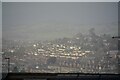
Newton Abbot : Town Scenery
Looking across the town of Newton Abbot.
Image: © Lewis Clarke
Taken: 31 Dec 2021
0.03 miles
2
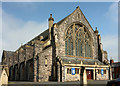
Church of St Mary, Abbotsbury, Newton Abbot
Grade II* listed, "1904-1906, dated 1905 on rainwater heads. By EH Sedding" https://www.historicengland.org.uk/listing/the-list/list-entry/1256768 . "Free Perpendicular Gothic ... the slightly-pointed, almost semicircular-arched west window has 2 chamfered mullions and swirling tracery made popular by the architect's uncle JD Sedding". Cherry & Pevsner call this window "wild".
The gate piers in the foreground are also listed https://www.historicengland.org.uk/listing/the-list/list-entry/1256771 .
Image: © Derek Harper
Taken: 20 May 2018
0.03 miles
3
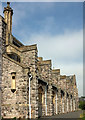
Church of St Mary, Abbotsbury, Newton Abbot
The buttressed south side of the grade II* listed church shown in Image
Image: © Derek Harper
Taken: 20 May 2018
0.03 miles
4
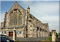
Church of St Mary, Abbotsbury, Newton Abbot
Abnother view of the grade II* listed church shown in Image], "1904-1906, dated 1905 on rainwater heads. By EH Sedding" https://www.historicengland.org.uk/listing/the-list/list-entry/1256768 .
The gate piers in the foreground are also listed https://www.historicengland.org.uk/listing/the-list/list-entry/1256771 . "They have plinths and larger blocks to the tops which are coved at the base and gabled to four sides over recessed trefoil-headed panels."
Image: © Derek Harper
Taken: 20 May 2018
0.04 miles
5
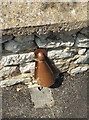
Cable protector (?), Newton Abbot
As seen 100 miles away in Bristol Image, and here on Thurlestone Road.
Image: © Derek Harper
Taken: 20 May 2018
0.04 miles
6
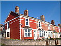
End of terrace, Fisher Road, Newton Abbot
The colourfully painted brick house is at the junction with Waverley Road.
Image: © Derek Harper
Taken: 5 Nov 2006
0.05 miles
7
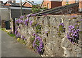
Campanula on wall, Newton Abbot
By Newton Abbot footpath 49, which follows this alley between Chelston Road and Milton Road.
Image: © Derek Harper
Taken: 20 May 2018
0.06 miles
8
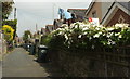
Back alley, Newton Abbot
Seen from Waverley Road, this alley runs between houses on Chelston Road and Fisher Road (right), with a white clematis on the wall.
Image: © Derek Harper
Taken: 20 May 2018
0.06 miles
9

Back alley, Newton Abbot
A service road between houses on Chelston Road (right) and Fisher Road, seen from Newton Abbot footpath 49.
Image: © Derek Harper
Taken: 20 May 2018
0.07 miles
10
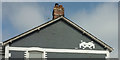
Space Invader, Newton Abbot
A blast from the past as an alien from the video game adorns a gable end facing Waverley Road.
Image: © Derek Harper
Taken: 20 May 2018
0.07 miles