IMAGES TAKEN NEAR TO
Mellons Walk, NEWTON ABBOT, TQ12 1YT
Introduction
This page details the photographs taken nearby to Mellons Walk, TQ12 1YT by members of the Geograph project.
The Geograph project started in 2005 with the aim of publishing, organising and preserving representative images for every square kilometre of Great Britain, Ireland and the Isle of Man.

There are currently over 7.5m images from over14,400 individuals and you can help contribute to the project by visiting https://www.geograph.org.uk
Image Map
Images are licensed for reuse under creativecommons.org/licenses/by-sa/2.0
Notes
- Clicking on the map will re-center to the selected point.
- The higher the marker number, the further away the image location is from the centre of the postcode.
Image Listing (15 Images Found)
Images are licensed for reuse under creativecommons.org/licenses/by-sa/2.0
Image
Details
Distance
1

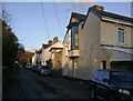
Devon Slates, Ashburton Road, Newton Abbot
Image: © Robin Stott
Taken: 20 Feb 2010
0.03 miles
3
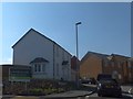
New housing estate on Littlejoy Road, Newton Abbot
Image: © David Smith
Taken: 2 Apr 2013
0.08 miles
5
Applegarth Avenue, Mile End
The west end, at its junction with Mile End Road
Image: © Robin Stott
Taken: 20 Feb 2010
0.11 miles
6
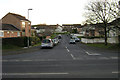
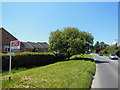
Chercombe Valley Road, Newton Abbot
Seen from its junction with the A383 Ashburton Road.
Image: © Robin Stott
Taken: 20 Feb 2010
0.13 miles
7
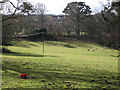
Sheep in a field near Mile End housing
Seen from Howton Road below Daracombe.
Image: © Robin Stott
Taken: 19 Feb 2010
0.13 miles
8
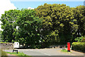
Junction at Mile End
Applegarth Avenue meets Mile End Road at this T junction. On the right is Elizabeth II postbox TQ12 8.
Image: © Derek Harper
Taken: 28 May 2018
0.16 miles
9
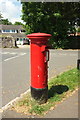
Postbox, Mile End
Elizabeth II postbox TQ12 8, on Applegarth Avenue, is shown in Image
Image: © Derek Harper
Taken: 28 May 2018
0.16 miles
10
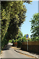
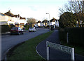
Mile End Road
From the junction with Applegarth Avenue. The road betrays occasional features of its earlier country lane status. Until recently it marked the limit of the built-up area of Newton Abbot, but estates have begun to spring up on the northwest side (left).
Image: © Derek Harper
Taken: 28 May 2018
0.19 miles