IMAGES TAKEN NEAR TO
Poppy Close, NEWTON ABBOT, TQ12 1SY
Introduction
This page details the photographs taken nearby to Poppy Close, TQ12 1SY by members of the Geograph project.
The Geograph project started in 2005 with the aim of publishing, organising and preserving representative images for every square kilometre of Great Britain, Ireland and the Isle of Man.

There are currently over 7.5m images from over14,400 individuals and you can help contribute to the project by visiting https://www.geograph.org.uk
Image Map
Images are licensed for reuse under creativecommons.org/licenses/by-sa/2.0
Notes
- Clicking on the map will re-center to the selected point.
- The higher the marker number, the further away the image location is from the centre of the postcode.
Image Listing (21 Images Found)
Images are licensed for reuse under creativecommons.org/licenses/by-sa/2.0
Image
Details
Distance
1
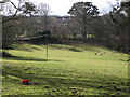
Sheep in a field near Mile End housing
Seen from Howton Road below Daracombe.
Image: © Robin Stott
Taken: 19 Feb 2010
0.07 miles
2
Western House, Howton Road
Massive Radiata Pine (Pinus radiata) on the left. It is an introduced 3-needled pine, hardy in the southwest.
The evergreen trees on the right could well be the same group that appears on the skyline in Image and on the right of Image In other words, clay waste from the Ringslade Quarry (which is in this square) is being spread beyond the screening trees.
Image: © Robin Stott
Taken: 19 Feb 2010
0.07 miles
3
Private grounds by Howton Road
Mad about conifers.
Image: © Robin Stott
Taken: 19 Feb 2010
0.07 miles
4
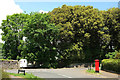
Junction at Mile End
Applegarth Avenue meets Mile End Road at this T junction. On the right is Elizabeth II postbox TQ12 8.
Image: © Derek Harper
Taken: 28 May 2018
0.14 miles
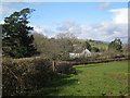
5
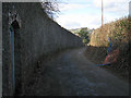
Daracombe's wall by Howton Road
Daracombe is a large house whose grounds are being developed for housing in "a major development and departure from the development plan", according to Teignbridge Council's planning site notice. The wall extends behind the camera for a similar distance to the junction with Mile End Road.
Image: © Robin Stott
Taken: 19 Feb 2010
0.15 miles
6
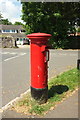
Postbox, Mile End
Elizabeth II postbox TQ12 8, on Applegarth Avenue, is shown in Image
Image: © Derek Harper
Taken: 28 May 2018
0.15 miles
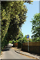
7
Applegarth Avenue, Mile End
The west end, at its junction with Mile End Road
Image: © Robin Stott
Taken: 20 Feb 2010
0.15 miles
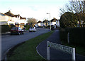
8
Mile End Road
From the junction with Applegarth Avenue. The road betrays occasional features of its earlier country lane status. Until recently it marked the limit of the built-up area of Newton Abbot, but estates have begun to spring up on the northwest side (left).
Image: © Derek Harper
Taken: 28 May 2018
0.16 miles
9
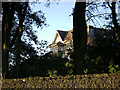
A glimpse of Daracombe
Daracombe is a substantial house whose grounds are to be developed with up to 85 dwellings.
Image: © Robin Stott
Taken: 20 Feb 2010
0.16 miles
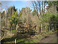
10
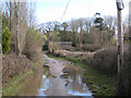
A low point on Howton Road
Daracombe Beacon can be seen through the trees.
Image: © Robin Stott
Taken: 19 Feb 2010
0.17 miles