IMAGES TAKEN NEAR TO
Wolborough Gate, NEWTON ABBOT, TQ12 1RA
Introduction
This page details the photographs taken nearby to Wolborough Gate, TQ12 1RA by members of the Geograph project.
The Geograph project started in 2005 with the aim of publishing, organising and preserving representative images for every square kilometre of Great Britain, Ireland and the Isle of Man.

There are currently over 7.5m images from over14,400 individuals and you can help contribute to the project by visiting https://www.geograph.org.uk
Image Map
Images are licensed for reuse under creativecommons.org/licenses/by-sa/2.0
Notes
- Clicking on the map will re-center to the selected point.
- The higher the marker number, the further away the image location is from the centre of the postcode.
Image Listing (180 Images Found)
Images are licensed for reuse under creativecommons.org/licenses/by-sa/2.0
Image
Details
Distance
1
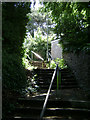
Steps on Wolborough Hill, Newton Abbot
Ascending from Bowden Hill to Courtenay Road.
Image: © Robin Stott
Taken: 26 Jun 2009
0.02 miles
2
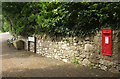
Postbox, Courtenay Road, Newton Abbot
George V postbox TQ12 12 is near the junction with South Road (left).
Image: © Derek Harper
Taken: 15 Jun 2020
0.05 miles
3
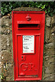
Postbox, Courtenay Road, Newton Abbot
A closer look at George V postbox TQ12 12, shown in context at Image
Image: © Derek Harper
Taken: 15 Jun 2020
0.05 miles
4
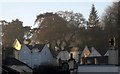
House on Wolborough Hill
Looking up the hill in morning sunlight from the top of Devon Square.
Image: © Derek Harper
Taken: 18 Dec 2012
0.06 miles
5

NHS car, Newton Abbot
An exuberant display of support for the NHS during the Covid-19 pandemic, on Courtenay Road.
Image: © Derek Harper
Taken: 15 Jun 2020
0.06 miles
6
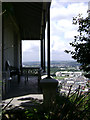
A balcony, Wolborough Hill, Newton Abbot
By chance, the balcony (or is it a verandah?) of No 10 Courtenay Road, a 19th century villa, can be seen from the street, such are the changes of viewpoint on this steep hill.
Image: © Robin Stott
Taken: 26 Jun 2009
0.07 miles
7
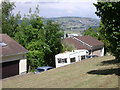
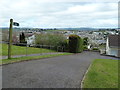
A steep strip of open space, Wolborough Hill, Newton Abbot
The 20th century has built houses where the Victorians chose not to. These have scarily steep drives. This scrap of open space by Courtenay Road gives glimpses of the surrounding country, here towards the A380 crossing of the Teign estuary Image (largely).
Image: © Robin Stott
Taken: 26 Jun 2009
0.07 miles
8
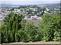
Boundary of a steep open space, Wolborough Hill (2)
The steepness allows a view over the boundary planting, here towards Knowles Hill, another 19th century hilltop suburb. The light-coloured scars in the landscape beyond are clay workings in the Bovey basin.
Image: © Robin Stott
Taken: 26 Jun 2009
0.07 miles
9
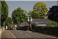
House and trees, Courtenay Road, Newton Abbot
A rather striking juxtaposition of colours as the road descends to a hairpin and the junction shown in Image
Image: © Derek Harper
Taken: 5 Jun 2013
0.07 miles
10
Newton Abbot - footpath from Courtenay Road
Image: © Chris Allen
Taken: 7 Apr 2012
0.07 miles