IMAGES TAKEN NEAR TO
Hill Park Road, NEWTON ABBOT, TQ12 1NU
Introduction
This page details the photographs taken nearby to Hill Park Road, TQ12 1NU by members of the Geograph project.
The Geograph project started in 2005 with the aim of publishing, organising and preserving representative images for every square kilometre of Great Britain, Ireland and the Isle of Man.

There are currently over 7.5m images from over14,400 individuals and you can help contribute to the project by visiting https://www.geograph.org.uk
Image Map
Images are licensed for reuse under creativecommons.org/licenses/by-sa/2.0
Notes
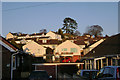
- Clicking on the map will re-center to the selected point.
- The higher the marker number, the further away the image location is from the centre of the postcode.
Image Listing (21 Images Found)
Images are licensed for reuse under creativecommons.org/licenses/by-sa/2.0
Image
Details
Distance
1
Motte and bailey castle, Highweek
Lost in suburbia. It explains the streetnames Castle Way, Castlewood Avenue and Norman Close. The mound is topped by a Radiata Pine (Pinus radiata), an introduced 3-needled pine that's hardy in the southwest.
Image: © Robin Stott
Taken: 20 Feb 2010
0.06 miles
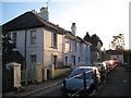
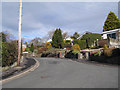
2
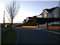
Hill Park Road, Highweek
Well-placed to enjoy the sunset – on a hill that became a Victorian suburb and subsequently a 20th century one.
Image: © Robin Stott
Taken: 20 Feb 2010
0.08 miles
4
Highweek Village
Postbox ID: TQ12 269. The van is about to descend Pit Hill Road.
Image: © Robin Stott
Taken: 19 Feb 2010
0.10 miles
6
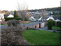
Rosemary Avenue, Newton Abbot
Looking towards Broadlands.
Image: © Robin Stott
Taken: 20 Feb 2010
0.12 miles
7
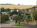
Castle Way, Newton Abbot
This short road connects Castlewood Avenue to Applegarth Avenue below. These estates jut out into the countryside west of Newton, as shown by the fields in the background.
Image: © Derek Harper
Taken: 19 Sep 2008
0.13 miles
8
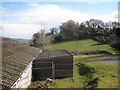
Scout hut and hill, Highweek
Highweek village is to the south (right) of the hill. Kingsteignton and its retail sheds appear on the left. The photographer position is a few metres away from that in Image Sadly, the inviting Daracombe Beacon is stoutly defended with barbed wire and dense hedges.
Image: © Robin Stott
Taken: 19 Feb 2010
0.14 miles
9
Gaze Hill, Highweek
A gaze at gables and gardens. The heathers-and-conifers combo has been promoted by the horticultural trade since at least the 1970s as a garden 'solution', to use 21st century parlance. Whether you like it or not, it is certainly colourful here.
Image: © Robin Stott
Taken: 19 Feb 2010
0.14 miles
10
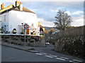
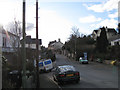
The very top of Pitt Hill Road
At its junction with Highweek Village.
Image: © Robin Stott
Taken: 19 Feb 2010
0.15 miles