IMAGES TAKEN NEAR TO
St. Marys Court, NEWTON ABBOT, TQ12 1FB
Introduction
This page details the photographs taken nearby to St. Marys Court, TQ12 1FB by members of the Geograph project.
The Geograph project started in 2005 with the aim of publishing, organising and preserving representative images for every square kilometre of Great Britain, Ireland and the Isle of Man.

There are currently over 7.5m images from over14,400 individuals and you can help contribute to the project by visiting https://www.geograph.org.uk
Image Map
Images are licensed for reuse under creativecommons.org/licenses/by-sa/2.0
Notes
- Clicking on the map will re-center to the selected point.
- The higher the marker number, the further away the image location is from the centre of the postcode.
Image Listing (236 Images Found)
Images are licensed for reuse under creativecommons.org/licenses/by-sa/2.0
Image
Details
Distance
1
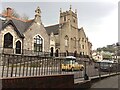
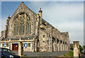
Former St Mary's Chapel-of-Ease, Highweek Street, Newton Abbot
Apparently not previously photographed for Geograph, this group of buildings was at one time held in great affection in the town. The chapel's origins may be earlier than the 13th century; the tower is mid-15th century. The demolition of the west side of the street (behind the camera) in the early 1980s to allow road-widening only exposed its state of disrepair. It was converted into flats in 1991 for the West Country Housing Association.
Further reading:
Newon Abbot Historical Buildings Trails. Newton Abbot Town and Great Western Railway Museum, published by Newton Abbot Town Council, ?1996.
Derek Beavis. Newton Abbot Past and Present. Stroud, Sutton Publishing Ltd, 2005. ISBN 0-7509-4062-X
Image: © Robin Stott
Taken: 27 Apr 2021
0.00 miles
2
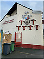
Church Institute, Newton Abbot
This Victorian building beside St Mary's Hall has for long been the YMCA, but has now been bought by the Newton Abbot and District Musical Comedy Society.
Image: © Derek Harper
Taken: 5 Nov 2006
0.02 miles
3
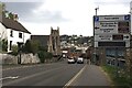
South end of Highweek Street, Newton Abbot
A closer view of the former St Mary's Chapel-of-Ease is Image The shop, lower right, is on the original line of Highweek Road, severed in the road-widening of the 1980s.
Image: © Robin Stott
Taken: 27 Apr 2021
0.02 miles
4
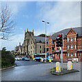
Lights on Highweek Street, Newton Abbot
The tower is of the former St Mary's Chapel-of-Ease Image The junction is with Bradley Lane, A382, which continues as Halcyon Road.
Image: © Robin Stott
Taken: 16 Feb 2022
0.02 miles
5
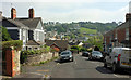
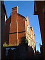
Waverley Road, Newton Abbot
Looking from in front of Image], towards the bend into Fisher Road, with a view ahead to Wolborough Hill.
Image: © Derek Harper
Taken: 20 May 2018
0.03 miles
6

Space Invader, Newton Abbot
A blast from the past as an alien from the video game adorns a gable end facing Waverley Road.
Image: © Derek Harper
Taken: 20 May 2018
0.04 miles
7
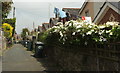
Back alley, Newton Abbot
Seen from Waverley Road, this alley runs between houses on Chelston Road and Fisher Road (right), with a white clematis on the wall.
Image: © Derek Harper
Taken: 20 May 2018
0.05 miles
8
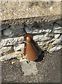
Cable protector (?), Newton Abbot
As seen 100 miles away in Bristol Image, and here on Thurlestone Road.
Image: © Derek Harper
Taken: 20 May 2018
0.05 miles
9
Swan Inn, Highweek Street, Newton Abbot
The stylish cows' and rams' heads assert a connection to the nearby livestock market, now closed. The pub is a listed building, Grade II https://historicengland.org.uk/listing/the-list/list-entry/1256931?section=official-list-entry The street frontage is seen in Image
Image: © Robin Stott
Taken: 16 Feb 2022
0.06 miles
10
Church of St Mary, Abbotsbury, Newton Abbot
Abnother view of the grade II* listed church shown in Image], "1904-1906, dated 1905 on rainwater heads. By EH Sedding" https://www.historicengland.org.uk/listing/the-list/list-entry/1256768 .
The gate piers in the foreground are also listed https://www.historicengland.org.uk/listing/the-list/list-entry/1256771 . "They have plinths and larger blocks to the tops which are coved at the base and gabled to four sides over recessed trefoil-headed panels."
Image: © Derek Harper
Taken: 20 May 2018
0.06 miles