IMAGES TAKEN NEAR TO
The Vinery, Montpellier Road, TORQUAY, TQ1 1TY
Introduction
This page details the photographs taken nearby to The Vinery, Montpellier Road, TQ1 1TY by members of the Geograph project.
The Geograph project started in 2005 with the aim of publishing, organising and preserving representative images for every square kilometre of Great Britain, Ireland and the Isle of Man.

There are currently over 7.5m images from over14,400 individuals and you can help contribute to the project by visiting https://www.geograph.org.uk
Image Map
Images are licensed for reuse under creativecommons.org/licenses/by-sa/2.0
Notes
- Clicking on the map will re-center to the selected point.
- The higher the marker number, the further away the image location is from the centre of the postcode.
Image Listing (1256 Images Found)
Images are licensed for reuse under creativecommons.org/licenses/by-sa/2.0
Image
Details
Distance
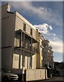
2
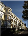
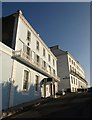
The Vinery, Torquay
This block of 32 apartments on Montpellier Road is "a recent (1987) development of flats with rounded bays in a neo-Georgian tradition, but using contemporary materials" http://www.torbay.gov.uk/torquay_harbour_conservation_area_appraisal.pdf .
Image: © Derek Harper
Taken: 10 Oct 2008
0.01 miles
4
Montpellier Road, Torquay
Image: © Derek Harper
Taken: 10 Oct 2008
0.02 miles
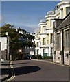
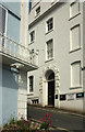
5
Buildings on Montpellier Road, Torquay
St John's House, the nearer building, was originally part of terrace on the site of St John's church, and dates from the 1820s http://list.english-heritage.org.uk/resultsingle.aspx?uid=1280032&searchtype=mapsearch . Beyond is The Vinery, also shown in Image
Image: © Derek Harper
Taken: 1 Nov 2012
0.02 miles
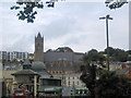
6
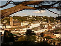
Torquay: view east from Warren Road
The rooftops of Torquay town centre, from the viewpoint in Warren Road.
Image: © Chris Downer
Taken: 28 Aug 2009
0.02 miles
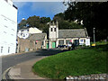
7
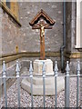
St. John the Apostle, Torquay. War Memorial
Set in at the exterior chancel end next to the parish centre. The cross type is known as a 'Calvary'. The names of those who lost their lives for the country are on a tablet to the left, fixed to the exterior church wall.
Image: © John C
Taken: 20 Oct 2014
0.02 miles
8
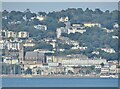
Torquay
Seen across Tor Bay from the end of Paignton Pier.
Image: © Colin Smith
Taken: 19 Jul 2021
0.03 miles
9
The Terrace, Torquay
The building on the left is Image, dating from the early C19 http://www.britishlistedbuildings.co.uk/en-390833-38-torquay . Beyond is the Terrace itself. See also Image
Image: © Derek Harper
Taken: 15 Dec 2010
0.03 miles
10
Buildings on The Terrace, Torquay
The street connects The Terrace to the higher Montpellier Road. On the left is Hagley House Image https://www.historicengland.org.uk/listing/the-list/list-entry/1218887 ; on the right is the west side of number 42, the end terrace of the terrace described at https://www.historicengland.org.uk/listing/the-list/list-entry/1280014 . "No.42 has a very large doorway on the 3-bay west end with rusticated vermiculated architrave, incised moulding to soffit and reveals of doorcase and Greek key moulding below fanlight".
Image: © Derek Harper
Taken: 8 Jun 2018
0.03 miles