IMAGES TAKEN NEAR TO
Middle Warberry Road, TORQUAY, TQ1 1SH
Introduction
This page details the photographs taken nearby to Middle Warberry Road, TQ1 1SH by members of the Geograph project.
The Geograph project started in 2005 with the aim of publishing, organising and preserving representative images for every square kilometre of Great Britain, Ireland and the Isle of Man.

There are currently over 7.5m images from over14,400 individuals and you can help contribute to the project by visiting https://www.geograph.org.uk
Image Map
Images are licensed for reuse under creativecommons.org/licenses/by-sa/2.0
Notes
- Clicking on the map will re-center to the selected point.
- The higher the marker number, the further away the image location is from the centre of the postcode.
Image Listing (183 Images Found)
Images are licensed for reuse under creativecommons.org/licenses/by-sa/2.0
Image
Details
Distance
1

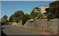
Sorrento, Lower Warberry Road
This purpose-built apartment block in the Warberries perhaps lacks some of the charm of the Italian town of the same name, but has good views.
Image: © Derek Harper
Taken: 25 Nov 2006
0.01 miles
2
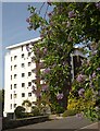
Middle Warberry Road
Southwood Court is a modern block of 18 flats.
Image: © Derek Harper
Taken: 27 Apr 2021
0.01 miles
3
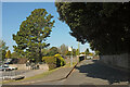
Bus stop, Middle Warberry Road
The final stop on the 64 bus route at the other end from the town centre, a service that used to stop almost outside our house until four years ago Image The car park serves Sorrento, a large block of flats.
Image: © Derek Harper
Taken: 27 Apr 2021
0.03 miles
4
Plant on Lower Warberry Road, Torquay
At first glance I thought this was Duke of Argyll's tea-tree, but I'm now (2022) certain it is Solanum crispum, the Chilean potato tree. See Image for a detailed close-up. In the background is Image
Image: © Derek Harper
Taken: 11 May 2009
0.04 miles
5

Plant on Lower Warberry Road, Torquay
A close-up of the flowers of Image This looks like Solanum crispum, the Chilean potato tree.
Image: © Derek Harper
Taken: 11 May 2009
0.04 miles
6
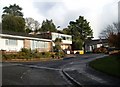
Bingfield Close, Torquay
Modern infill along Lower Warberry Road, probably on the plot of a vanished Victorian villa.
Image: © Derek Harper
Taken: 25 Nov 2006
0.05 miles
7
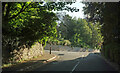
Junction, Warberries
Stitchill Road meets Lower Warberry Road.
Image: © Derek Harper
Taken: 14 Jun 2021
0.06 miles
8
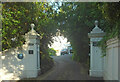
Villa entrance, Stitchill Road, Torquay
The gate piers and gate are listed https://historicengland.org.uk/listing/the-list/list-entry/1218673?section=official-list-entry although the latter has been removed. The blue plaque on the left commemorates a stay by Isambard Kingdom Brunel and his wife from July to November 1848 in the villa glimpsed up the drive. The named Vomero, it is also listed https://historicengland.org.uk/listing/the-list/list-entry/1280008?section=official-list-entry : "One of the earlier Torquay villas".
Image: © Derek Harper
Taken: 14 Jun 2021
0.06 miles
9
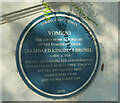
Blue plaque, Stitchill Road, Torquay
Also shown in Image "Vomero: the first home in Torquay of the famous engineer Isambard Kingdom Brunel b.1806-d.1859 whilst organising the arrangements for his estate at Watcombe, Torquay, Brunel and his wife stayed here from July to November 1848" http://openplaques.org/plaques/1860 . I should add that the wall to which it is attached is listed https://historicengland.org.uk/listing/the-list/list-entry/1218673?section=official-list-entry .
Image: © Derek Harper
Taken: 14 Jun 2021
0.06 miles
10
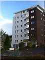
Ellesmere, Lower Warberry Road, Torquay
Ellesmere consists of two blocks of 26 flats in 2 acres of grounds overlooking Torbay; this is the eastern of the two.
Image: © Derek Harper
Taken: 25 Nov 2006
0.06 miles