IMAGES TAKEN NEAR TO
Higher Warberry Road, TORQUAY, TQ1 1SE
Introduction
This page details the photographs taken nearby to Higher Warberry Road, TQ1 1SE by members of the Geograph project.
The Geograph project started in 2005 with the aim of publishing, organising and preserving representative images for every square kilometre of Great Britain, Ireland and the Isle of Man.

There are currently over 7.5m images from over14,400 individuals and you can help contribute to the project by visiting https://www.geograph.org.uk
Image Map
Images are licensed for reuse under creativecommons.org/licenses/by-sa/2.0
Notes
- Clicking on the map will re-center to the selected point.
- The higher the marker number, the further away the image location is from the centre of the postcode.
Image Listing (172 Images Found)
Images are licensed for reuse under creativecommons.org/licenses/by-sa/2.0
Image
Details
Distance
1
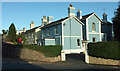
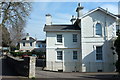
Villa, Wellswood
A large semi by the junction of Higher Warberry Road and Ellesmere Road.
Image: © Derek Harper
Taken: 10 Nov 2020
0.03 miles
2
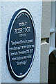
Blue plaque to Peter Cook
Installed on the wall of Kinbrae, Middle Warberry Road, Torquay in 2014. "Peter Cook (1937-1995) Voted one of Britain's greatest comedians and a writer of note was born here November 17th 1937 when the house was called "Shearbridge"". But here's a thing. Harry Thompson's "Biography Of Peter Cook", published in 1997, describes Bythorn in Bronshill Road, which Peter's grandmother had recently bought, as the house where Peter's mother was living when he was born at St Chad's nursing home, and where he spent his early childhood https://books.google.co.uk/books?id=RMd6JHis3REC&pg=PT16&lpg=PT16&dq=%22bythorn%22+Peter+Cook+Bronshill&source=bl&ots=pBBxsbqCMf&sig=ACfU3U0Ngsv9iGQHAjYqIMbtNKi90GwXoA&hl=en&sa=X&ved=2ahUKEwiB8PT5gIXtAhWCilwKHfh7AsMQ6AEwAnoECAEQAg#v=onepage&q=%22bythorn%22%20Peter%20Cook%20Bronshill&f=false . Both cannot be right!
Image: © Derek Harper
Taken: 10 Nov 2020
0.04 miles
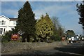
3
Barrington Road, Wellswood
The building on the right, Stanfield, is divided into 14 flats.
Image: © Derek Harper
Taken: 10 Nov 2020
0.04 miles
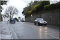
5
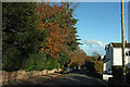
Barrington Road, Torquay
Looking west from the Babbacombe Road end.
Image: © Jaggery
Taken: 6 Jul 2014
0.06 miles
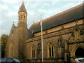
7
Hotel, Babbacombe Road, Torquay
The Ansteys Lea guest house beside the A379 in Wellswood. On the right is Woodrow, a retirement home.
Image: © Derek Harper
Taken: 11 Mar 2016
0.06 miles
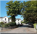
8
Villas in Wellswood
A pair of classic Torbay villas at the junction of Babbacombe Road and Asheldon Road.
Image: © Derek Harper
Taken: 11 Mar 2016
0.07 miles
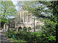
9
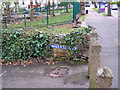
Low level signpost
This Victorian 'gents' sign points down an alley between Ilsham Primary School and St Matthias’ Church, just off the Babbacombe Road. There is no 'ladies' equivalent, and no promised facility either in or at the end of the alley...
Image: © Richard Dorrell
Taken: 27 Mar 2010
0.07 miles